آخرین عکس های طبیعت و مناظر ایران
بهرام عابدینی
آخرین عکس های طبیعت و مناظر ایران
آخرین عکس های طبیعت و مناظر ایران
بهرام عابدینی
بهرام عابدینی
Website Language

")
Farsi Description:
قله پورا از جنوب به روستای کندر ، از شمال به روستای ابهرک و ارنگه ، از غرب به روستای آدران و از شرق بر روی خط الراس قلل چال ، سیوچال ، درزو و پشته بند محراب چشمه شاهی قله پهنه سار امتداد دارد مسیرهای صعود جاده قدیم کندور دره گلنا و آبشار نمرک و روستای ابهرک ارتغاع قله دوهزارو نصد متر است
به این عکس امتیاز دهید.
این عکس توسط بهرام عابدینی از تپه ها و طبیعت اطراف این منطقه گرفته شده است. برای خرید این عکس یا عکس های دیگر از طریق وبسایت یا تلفن با ما تماس بگیرید.
توضیحات انگلیسی:
Pura Peak is bordered to the south by the village of Kondor, to the north by the villages of Abharak and Arangeh, to the west by the village of Adran, and to the east along the ridge line of Chal, Sivchal, Darzu, and Pusht-e Band Mehrab Cheshmeh Shahi peaks, extending to Pahne Sar Peak. The ascent routes include the old Kondor Road, Golna Valley, Namrak Waterfall, and the village of Abharak. The peak's elevation is 2,900 meters.
Please rate this picture.
This picture is taken by Bahram Abedini. If you want to purchase this picture or any other around this area please contact us through website, email or phone.
We sell pictures digitally in Large format and internationally through secure paypal payment in the US.
Farsi Description:
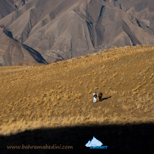
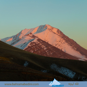
قله لیچه به ارتفاع 2900 در استان البرز در شرق روستای کندور و در غرب روستای واریش تهران قرار دارد مسیرهای صعود روستای کندور و روستای واریش میباشد لیچه همجوار با کوه چشمه شاهی ودر ادامه یال به قله لیز و لیزان متصل می شود ارتفاع قله 2900 متر واین عکس از جاده قدیم کندور زیر قله پورا گرفته شده
به این عکس امتیاز دهید.
این عکس توسط بهرام عابدینی از تپه ها و طبیعت اطراف این منطقه گرفته شده است. برای خرید این عکس یا عکس های دیگر از طریق وبسایت یا تلفن با ما تماس بگیرید.
توضیحات انگلیسی:
"Liche Peak, with an elevation of 2900 meters, is located in Alborz Province, east of Kondor village and west of Varish village in Tehran. The ascent routes are from Kondor village and Varish village. Liche is adjacent to Cheshmeh Shahi mountain and continues along the ridge to connect to Liz and Lizan peaks. The elevation of the peak is 2900 meters, and this photo was taken from the old Kondor road below Pura Peak."
Please rate this picture.
This picture is taken by Bahram Abedini. If you want to purchase this picture or any other around this area please contact us through website, email or phone.
We sell pictures digitally in Large format and internationally through secure paypal payment in the US.
Farsi Description:
قله هفت خوان یکی از قلل زیبای رشتهکوه البرز غربی است که در نزدیکی روستای سپهسالار قرار دارد و ارتفاع آن به ۳۹۷۰ متر میرسد. در زمستان سال ۱۳۵۹، صعود به این قله به دلیل شرایط سخت آب و هوایی و برف سنگین، چالشی بزرگ برای کوهنوردان بود.
در آن سال، گروهی از کوهنوردان با تجهیزات محدود و بدون امکانات پیشرفته امروزی، تصمیم به صعود به قله هفت خوان گرفتند. مسیر صعود از روستای سپهسالار آغاز شد و کوهنوردان با عبور از یال جنوبی و گردنه خرگوش، به سمت قله حرکت کردند. شرایط سخت زمستانی، از جمله برف سنگین و بادهای شدید، این صعود را بسیار دشوار کرد.
با وجود این چالشها، کوهنوردان با تلاش و پشتکار فراوان توانستند به قله برسند و این صعود به عنوان یکی از دستاوردهای مهم کوهنوردی در آن زمان به شمار میرفت. این صعود نشاندهنده اراده و عزم راسخ کوهنوردان در مواجهه با شرایط سخت طبیعی بود.
به این عکس امتیاز دهید.
این عکس توسط بهرام عابدینی از تپه ها و طبیعت اطراف این منطقه گرفته شده است. برای خرید این عکس یا عکس های دیگر از طریق وبسایت یا تلفن با ما تماس بگیرید.
توضیحات انگلیسی:
Mount Haft Khān is one of the beautiful peaks of the western Alborz mountain range, located near the village of Sepahsalar, with an elevation of 3,970 meters (13,024.93 feet.). In the winter of 1980, climbing this peak was a significant challenge for mountaineers due to harsh weather conditions and heavy snowfall.
That year, a group of mountaineers, with limited equipment and without the advanced facilities available today, decided to climb Mount Haft Khān. The ascent route started from the village of Sepahsalar, and the climbers moved towards the peak by passing through the southern ridge and Kharghosh Pass. The harsh winter conditions, including heavy snow and strong winds, made this climb very difficult.
Despite these challenges, the mountaineers, with great effort and perseverance, managed to reach the summit. This climb was considered one of the significant achievements in mountaineering at that time. It demonstrated the determination and strong will of mountaineers in facing tough natural conditions.
Please rate this picture.
This picture is taken by Bahram Abedini. If you want to purchase this picture or any other around this area please contact us through website, email or phone.
Farsi description:
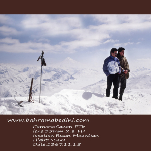
قله ریزان در منطقه لواسانات و نزدیکی روستای افجه قرار دارد و با ارتفاع ۳۵۷۰ متر یکی از مقاصد محبوب کوهنوردان است. مسیر اصلی صعود از دشت هویج آغاز میشود و حدود ۵ ساعت طول میکشد. بهترین زمان برای صعود به این قله، فصل بهار و تابستان است
به این عکس امتیاز دهید.
این عکس توسط بهرام عابدینی از تپه ها و طبیعت اطراف این منطقه گرفته شده است. برای خرید این عکس یا عکس های دیگر از طریق وبسایت یا تلفن با ما تماس بگیرید.
توضیحات انگلیسی:
Mount Rizan is located in the Lavasanat region near the village of Afjeh, with an elevation of 3,570 meters. It's a popular destination for hikers. The main route to the peak starts from the Carrot Plain (Dasht-e Havij) and takes about 5 hours to complete. The best time to hike this peak is during spring and summer.
Please rate this picture.
This picture is taken by Bahram Abedini. If you want to purchase this picture or any other around this area please contact us through website, email or phone.
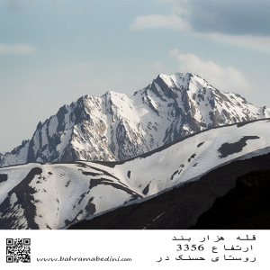
قله هزار بند در رشتهکوه البرز مرکزی و استان البرز قرار دارد. این قله با ارتفاع ۳۳۵۰ متر، به دلیل ساختار سنگی و صخرهای خود، نیاز به تجربه نسبی در کوهنوردی دارد. مسیر اصلی صعود از روستای حسنکدر شروع میشود و حدود ۵.۵ ساعت طول میکشد.
به این عکس امتیاز دهید.
این عکس توسط بهرام عابدینی از تپه ها و طبیعت اطراف این منطقه گرفته شده است. برای خرید این عکس یا عکس های دیگر از طریق وبسایت یا تلفن با ما تماس بگیرید.
Mount Hezarband is located in the central Alborz mountain range in Alborz Province. This peak, standing at 3,350 meters, is known for its rocky and rugged terrain, requiring some mountaineering experience. The main ascent route starts from the village of Hasanakdar and takes about 5.5 hours to reach the summit.
Literal translation of Hezarband means thousand shackles .
Please rate this picture.
This picture is taken by Bahram Abedini. If you want to purchase this picture or any other around this area please contact us through website, email or phone.
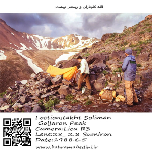
کوه کلجاران و رستم نیشت دو قله برجسته در توده تخت سلیمان در رشتهکوه البرز ایران هستند. کوه کلجاران با ارتفاع تقریبی ۴۴۳۱ متر (۱۴۵۳۷ فوت) به دلیل مسیرهای پیادهروی چالشبرانگیز و درههای مهآلود و سرسبز که تحت تأثیر دریای خزر نزدیک قرار دارند، شناخته شده است. پیادهروی به گردنه کلجاران مناظر خیرهکنندهای از قلهها و درههای اطراف ارائه میدهد.
رستم نیشت با ارتفاع تقریبی ۴۴۲۶ متر (۱۴۵۲۰ فوت)، دارای یک فلات کوچک مثلثی با سه قله نوکتیز و دامنههای شیبدار پوشیده از سنگریزه است که به شدت به دره سهزار میافتند. صعود به رستم نیشت اغلب از روستای ونداربن آغاز میشود و از پناهگاه سرچال عبور میکند، که مناظر خیرهکنندهای از قلههای هفتخان و یخچال هفتخان را ارائه میدهد.
هر دو کوه پیادهرویهای دشوار و مناظر دیدنی ارائه میدهند و مقصدهای پاداشبخش برای کوهنوردان با تجربه هستند.
به این عکس امتیاز دهید.
این عکس توسط بهرام عابدینی از تپه ها و طبیعت اطراف این منطقه گرفته شده است. برای خرید این عکس یا عکس های دیگر از طریق وبسایت یا تلفن با ما تماس بگیرید.
Kaljaran Mountain and Rostam Nisht are two prominent peaks in the Takhte Soleyman Massif of the Alborz mountain range in Iran. Kaljaran Mountain stands at approximately 4,431 meters (14,537 feet) and is known for its challenging hiking routes and lush, fog-filled valleys influenced by the nearby Caspian Sea. The hike to Kaljaran Pass offers stunning views of the surrounding peaks and valleys.
Rostam Nisht, with an elevation of around 4,426 meters (14,520 feet), features a small triangular plateau with three pointy summits and steep scree-covered western slopes. The climb to Rostam Nisht often starts from the village of Vandar Bon and passes through the Sar Chal Shelter, leading to breathtaking views of the Haft Khan Peaks and the Haft Khan Glacier.
Both mountains offer demanding hikes and spectacular scenery, making them rewarding destinations for experienced hikers.
Please rate this picture.
This picture is taken by Bahram Abedini. If you want to purchase this picture or any other around this area please contact us through website, email or phone.
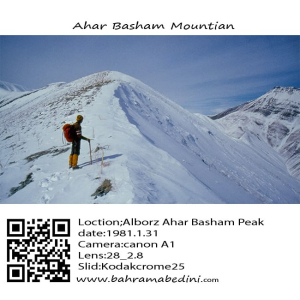
قله آهار بشم با ارتفاع ۳۱۳۰ متر در رشتهکوههای البرز مرکزی و در نزدیکی روستای آهار قرار دارد. مسیر صعود به این قله از روستای آهار آغاز میشود و از میان مناظر طبیعی زیبا و باغهای سرسبز عبور میکند، که آن را به مقصدی محبوب برای کوهنوردان و طبیعتگردان تبدیل کرده است.
به این عکس امتیاز دهید.
این عکس توسط بهرام عابدینی از تپه ها و طبیعت اطراف این منطقه گرفته شده است. برای خرید این عکس یا عکس های دیگر از طریق وبسایت یا تلفن با ما تماس بگیرید.
Ahar Bashm Mountain, also known as Kūh-e Āhār Bashm, is a prominent peak located in Tehran, Iran, standing at an elevation of 3,129 meters (10,266 feet). This mountain is a popular destination for hikers and nature enthusiasts due to its scenic trails and relatively gentle slopes. The hike typically begins from the village of Āhār and passes through lush gardens and alongside a river, leading to a shrine (Imamzadeh) and a picturesque waterfall. Despite the moderate difficulty of the hike, it’s important for hikers to carry sufficient water as there are no natural springs along the route.
Please rate this picture.
This picture is taken by Bahram Abedini. If you want to purchase this picture or any other around this area please contact us through website, email or phone.
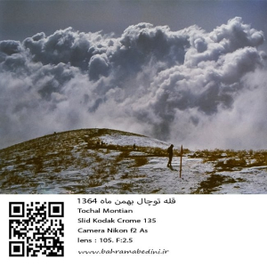
عکسی از قله توچال در سال 1364 در ماه بهمن
مشخصات دوربین و لنز در زیر عکس ذکر شده است.
به این عکس امتیاز دهید.
این عکس توسط بهرام عابدینی از تپه ها و طبیعت اطراف این منطقه گرفته شده است. برای خرید این عکس یا عکس های دیگر از طریق وبسایت یا تلفن با ما تماس بگیرید.
English description:
In 1985, Tochal Mountain in Iran, part of the Alborz range, was a popular destination for its stunning views and rugged terrain. Standing at 3,963 meters, it featured various peaks and trails for hikers and climbers. The Tochal Telecabin, a gondola lift, provided easy access to higher altitudes and the ski resort. The mountain’s proximity to Tehran made it a quick escape for outdoor enthusiasts, with shelters like Shirpala and Siahsang offering rest stops. Overall, Tochal was a cherished natural landmark blending adventure and tranquility.
Please rate this picture.
This picture is taken by Bahram Abedini. If you want to purchase this picture or any other around this area please contact us through website, email or phone.
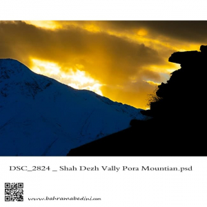
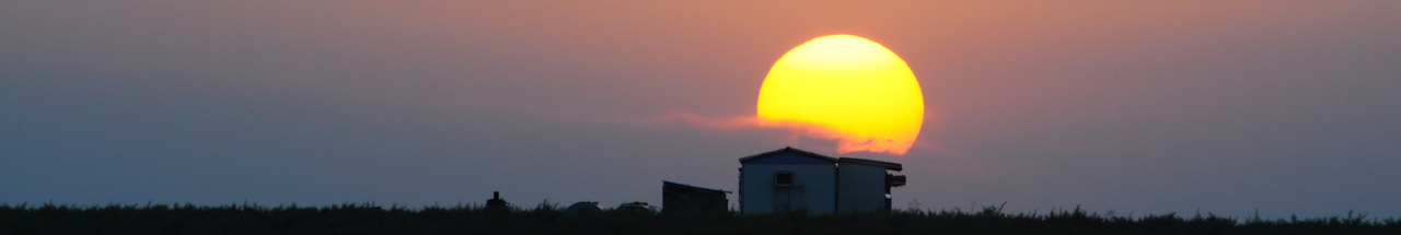
The valley of Shah dej in a sunset
This picture has been taken on my recent hiking in the region , the summit in the picture is the Poora peak
دره شاه دژ و قله پورا در پس زمینه
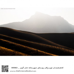
قله خان گرمز در شهر تویسرکان در نزدیکی همدان
The Mountain of Khan-garmaz
In the Vicinity of Hamedan (modern Hegmatane) the capital of the Medes.
A beautiful pristine nature with a good wildlife.