آخرین عکس های طبیعت و مناظر ایران
بهرام عابدینی
آخرین عکس های طبیعت و مناظر ایران
آخرین عکس های طبیعت و مناظر ایران
بهرام عابدینی
بهرام عابدینی
Website Language

")
Farsi Description:
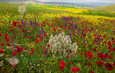
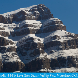
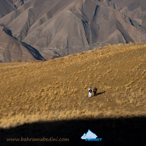
در استان لرستان، دره سزار یکی از زیباترین درههای کوهستانی است که در نزدیکی شهرستان دورود قرار دارد و رودخانه سزار با آب خروشان و طبیعت سرسبز از میان آن عبور میکند. در امتداد این منطقه، قله پریز با ارتفاعی حدود ۳۱۰۰ متر از جاذبههای مهم کوهنوردی به شمار میآید. این قله چشماندازهای گسترده، چشمههای زلال و غارهای طبیعی دارد و مسیر صعود آن از دورود آغاز میشود. ترکیب رودخانه سزار، صخرههای آهکی، پوشش گیاهی متنوع و هوای پاک، این منطقه را به مقصدی محبوب برای طبیعتگردان و کوهنوردان تبدیل کرده است.
به این عکس امتیاز دهید.
این عکس توسط بهرام عابدینی از تپه ها و طبیعت اطراف این منطقه گرفته شده است. برای خرید این عکس یا عکس های دیگر از طریق وبسایت یا تلفن با ما تماس بگیرید.
توضیحات انگلیسی:
In Lorestan Province, Sezar Valley is one of the most beautiful mountain gorges, located near Dorud, where the Sezar River flows through with rushing waters and lush scenery. Along this area, Pariz Peak, standing at about 3,100 meters, is a major attraction for mountaineers. The peak offers wide panoramic views, clear springs, and natural caves, with the main climbing route starting from Dorud. The combination of the Sezar River, limestone cliffs, diverse vegetation, and fresh mountain air makes this region a popular destination for nature lovers and hikers.
Please rate this picture.
This picture is taken by Bahram Abedini. If you want to purchase this picture or any other around this area please contact us through website, email or phone.
We sell pictures digitally in Large format and internationally through secure paypal payment in the US. Just let us know which picture you like through here: Contact-us
Farsi Description:
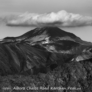
قلهٔ کرچان در رشتهکوه البرز مرکزی واقع شده و یکی از قلههای محبوب کوهنوردان است. این قله با ارتفاعی حدود ۳۹۰۰ متر (بسته به مسیر اندازهگیری) چشماندازی وسیع به دشت هراز، قلههای دماوند و منطقهٔ پلور دارد. مسیرهای صعود معمولاً از روستاهای نوا یا پلور آغاز میشود و به دلیل مناظر بکر، سکوت کوهستان و نزدیکی به تهران مقصدی جذاب برای صعود یکروزه یا دوروزه است.
به این عکس امتیاز دهید.
این عکس توسط بهرام عابدینی از تپه ها و طبیعت اطراف این منطقه گرفته شده است. برای خرید این عکس یا عکس های دیگر از طریق وبسایت یا تلفن با ما تماس بگیرید.
توضیحات انگلیسی:
Karchan Peak is located in the Central Alborz mountain range and is a popular destination for climbers. Standing at an elevation of about 3,900 m, it offers wide, breathtaking views of the Haraz plain, Mount Damavand, and the surrounding Plour region. The usual ascent routes start from the villages of Nava or Plour, making it an attractive choice for a one-day or two-day climb thanks to its pristine landscapes, peaceful mountain atmosphere, and convenient access from Tehran.
Please rate this picture.
This picture is taken by Bahram Abedini. If you want to purchase this picture or any other around this area please contact us through website, email or phone.
We sell pictures digitally in Large format and internationally through secure paypal payment in the US.
Farsi Description:
قلهٔ کرکوه با ارتفاع ۳۱۰۰ متر در درهٔ خور و سیجان واقع شده است. این قله با قلههای پهنهحصار و چال ناجی یال مشترک دارد و آبشارهای زیبای پنجهپلنگ و رفک در دامنههای آن قرار گرفتهاند. منطقهٔ کرکوه با طبیعت بکر، پوشش گیاهی متنوع و چشماندازهای کوهستانی، یکی از مقاصد محبوب کوهنوردان و طبیعتگردان در نزدیکی تهران به شمار میرود.
به این عکس امتیاز دهید.
این عکس توسط بهرام عابدینی از تپه ها و طبیعت اطراف این منطقه گرفته شده است. برای خرید این عکس یا عکس های دیگر از طریق وبسایت یا تلفن با ما تماس بگیرید.
توضیحات انگلیسی:
Mount Karkouh, standing at an elevation of 3,100 meters, is located in the Khur and Sijan valley. It shares a ridge with the peaks of Pahneh Hisar and Chal Naji, and the beautiful waterfalls of Panjeh Palang and Rafak lie at its base. The Karkouh region, with its pristine nature, diverse vegetation, and stunning mountain landscapes, is a popular destination for hikers and nature enthusiasts near Tehran.
Please rate this picture.
This picture is taken by Bahram Abedini. If you want to purchase this picture or any other around this area please contact us through website, email or phone.
We sell pictures digitally in Large format and internationally through secure paypal payment in the US.
Farsi Description:
کوه پهنه حصار یک قله برجسته در کوههای البرز مرکزی در شمال ایران، نزدیک روستای سنگان بالا است. این کوه به خاطر مسیرهای دیدنی، مناظر متنوع و تنوع زیستی غنی خود شناخته شده است. این منطقه شامل آبشار چشمگیر سنگان نیز میشود که آن را به مقصدی محبوب برای کوهنوردان و علاقهمندان به طبیعت تبدیل کرده است.
به این عکس امتیاز دهید.
این عکس توسط بهرام عابدینی از تپه ها و طبیعت اطراف این منطقه گرفته شده است. برای خرید این عکس یا عکس های دیگر از طریق وبسایت یا تلفن با ما تماس بگیرید.
توضیحات انگلیسی:
The Mountain of Pahne Hesar is a prominent peak in the Central Alborz Mountains of northern Iran, near the village of Sangan Bala. It's known for its scenic trails, diverse landscapes, and rich biodiversity. The area includes the impressive Sangan Waterfall, making it a popular destination for hikers and nature enthusiasts.
Please rate this picture.
This picture is taken by Bahram Abedini. If you want to purchase this picture or any other around this area please contact us through website, email or phone.
We sell pictures digitally in Large format and internationally through secure paypal payment in the US.
Farsi Description:
قله پورا از جنوب به روستای کندر ، از شمال به روستای ابهرک و ارنگه ، از غرب به روستای آدران و از شرق بر روی خط الراس قلل چال ، سیوچال ، درزو و پشته بند محراب چشمه شاهی قله پهنه سار امتداد دارد مسیرهای صعود جاده قدیم کندور دره گلنا و آبشار نمرک و روستای ابهرک ارتغاع قله دوهزارو نصد متر است
به این عکس امتیاز دهید.
این عکس توسط بهرام عابدینی از تپه ها و طبیعت اطراف این منطقه گرفته شده است. برای خرید این عکس یا عکس های دیگر از طریق وبسایت یا تلفن با ما تماس بگیرید.
توضیحات انگلیسی:
Pura Peak is bordered to the south by the village of Kondor, to the north by the villages of Abharak and Arangeh, to the west by the village of Adran, and to the east along the ridge line of Chal, Sivchal, Darzu, and Pusht-e Band Mehrab Cheshmeh Shahi peaks, extending to Pahne Sar Peak. The ascent routes include the old Kondor Road, Golna Valley, Namrak Waterfall, and the village of Abharak. The peak's elevation is 2,900 meters.
Please rate this picture.
This picture is taken by Bahram Abedini. If you want to purchase this picture or any other around this area please contact us through website, email or phone.
We sell pictures digitally in Large format and internationally through secure paypal payment in the US.
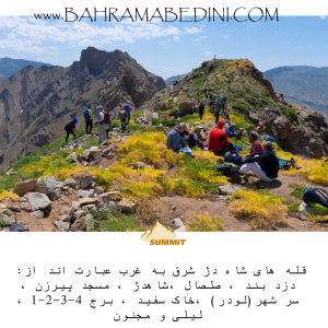
Farsi Description:
شاه دژ، دزدبند، صلصال، مسجد پیرزن، سر شهر (لودر)، خاک سفید، قلههای برج، و کوه لیلی و مجنون هر کدام دارای ویژگیهای خاص و تاریخی هستند. شاه دژ و قلههای برج در رشتهکوه البرز قرار دارند و به دلیل دیوارههای سنگی و چشماندازهای زیبا، مقصدی محبوب برای کوهنوردان هستند. دزدبند و صلصال قلعههای تاریخی با معماری خاص و موقعیت استراتژیک هستند. مسجد پیرزن در بوشهر توسط پیرزنی ساخته شده و برهسر در گیلان به دلیل طبیعت بکر و پوشش گیاهی انبوه، مقصدی محبوب برای گردشگران است. کوه سفید به دلیل معادن گچ خود معروف است و داستان عاشقانه لیلی و مجنون به کوه لیلی و مجنون اشاره دارد.
به این عکس امتیاز دهید.
این عکس توسط بهرام عابدینی از تپه ها و طبیعت اطراف این منطقه گرفته شده است. برای خرید این عکس یا عکس های دیگر از طریق وبسایت یا تلفن با ما تماس بگیرید.
توضیحات انگلیسی:
Shah Dej, Dozdband, Salsal, Masjed Pirzan, Sar Shahr (Loader), Khak Sefid, Borj Peaks, and Lili and Majnun Mountain each have unique historical and natural features. Shah Dej and Borj Peaks are located in the Alborz mountain range and are popular destinations for mountaineers due to their rocky walls and beautiful landscapes. Dozdband and Salsal are historical castles with distinctive architecture and strategic locations. Masjed Pirzan in Bushehr was built by an elderly woman, and Bareh Sar in Gilan is a popular tourist destination due to its pristine nature and dense vegetation. Khak Sefid is known for its gypsum mines, and the romantic story of Lili and Majnun is associated with Lili and Majnun Mountain.
Please rate this picture.
This picture is taken by Bahram Abedini. If you want to purchase this picture or any other around this area please contact us through website, email or phone.
We sell pictures digitally in Large format and internationally through secure paypal payment in the US.
Farsi Description:
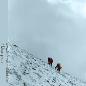
قله هفت خوان یکی از قلل زیبای رشتهکوه البرز غربی است که در نزدیکی روستای سپهسالار قرار دارد و ارتفاع آن به ۳۹۷۰ متر میرسد. در زمستان سال ۱۳۵۹، صعود به این قله به دلیل شرایط سخت آب و هوایی و برف سنگین، چالشی بزرگ برای کوهنوردان بود.
در آن سال، گروهی از کوهنوردان با تجهیزات محدود و بدون امکانات پیشرفته امروزی، تصمیم به صعود به قله هفت خوان گرفتند. مسیر صعود از روستای سپهسالار آغاز شد و کوهنوردان با عبور از یال جنوبی و گردنه خرگوش، به سمت قله حرکت کردند. شرایط سخت زمستانی، از جمله برف سنگین و بادهای شدید، این صعود را بسیار دشوار کرد.
با وجود این چالشها، کوهنوردان با تلاش و پشتکار فراوان توانستند به قله برسند و این صعود به عنوان یکی از دستاوردهای مهم کوهنوردی در آن زمان به شمار میرفت. این صعود نشاندهنده اراده و عزم راسخ کوهنوردان در مواجهه با شرایط سخت طبیعی بود.
به این عکس امتیاز دهید.
این عکس توسط بهرام عابدینی از تپه ها و طبیعت اطراف این منطقه گرفته شده است. برای خرید این عکس یا عکس های دیگر از طریق وبسایت یا تلفن با ما تماس بگیرید.
توضیحات انگلیسی:
Mount Haft Khān is one of the beautiful peaks of the western Alborz mountain range, located near the village of Sepahsalar, with an elevation of 3,970 meters (13,024.93 feet.). In the winter of 1980, climbing this peak was a significant challenge for mountaineers due to harsh weather conditions and heavy snowfall.
That year, a group of mountaineers, with limited equipment and without the advanced facilities available today, decided to climb Mount Haft Khān. The ascent route started from the village of Sepahsalar, and the climbers moved towards the peak by passing through the southern ridge and Kharghosh Pass. The harsh winter conditions, including heavy snow and strong winds, made this climb very difficult.
Despite these challenges, the mountaineers, with great effort and perseverance, managed to reach the summit. This climb was considered one of the significant achievements in mountaineering at that time. It demonstrated the determination and strong will of mountaineers in facing tough natural conditions.
Please rate this picture.
This picture is taken by Bahram Abedini. If you want to purchase this picture or any other around this area please contact us through website, email or phone.
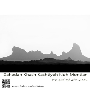
کوه تفتان، که به نام کوه کشتی نوح نیز شناخته میشود، یکی از مهمترین و مرتفعترین کوههای جنوب شرقی ایران است. این کوه در نزدیکی شهرستان خاش و در فاصله حدود ۱۰۰ کیلومتری از زاهدان قرار دارد. تفتان با ارتفاع ۳۹۴۱ متر از سطح دریا، به عنوان یک کوه آتشفشانی فعال شناخته میشود و دارای چهار قله اصلی به نامهای چهل تن، مادرکوه، صبح کوه و نرکوه است.
ویژگیهای برجسته کوه تفتان:
فعالیتهای آتشفشانی: تفتان به دلیل فعالیتهای آتشفشانی خود مشهور است و از دهانههای آن گازهای گوگردی به طور مداوم خارج میشود.
چشمههای آب معدنی: در اطراف کوه، چشمههای آب معدنی متعددی وجود دارد که به دلیل خواص درمانی خود، مورد توجه گردشگران و محلیها قرار گرفتهاند.
طبیعت بکر: مناظر طبیعی زیبا و بکر این منطقه، شامل پوشش گیاهی متنوع و حیات وحش غنی، این کوه را به مقصدی محبوب برای طبیعتگردان و کوهنوردان تبدیل کرده است.
مسیرهای کوهنوردی: مسیرهای مختلفی برای صعود به قلههای تفتان وجود دارد که هر کدام چالشها و زیباییهای خاص خود را دارند
به این عکس امتیاز دهید.
این عکس توسط بهرام عابدینی از تپه ها و طبیعت اطراف این منطقه گرفته شده است. برای خرید این عکس یا عکس های دیگر از طریق وبسایت یا تلفن با ما تماس بگیرید.
Mount Taftan, also known as Noah’s Ark Mountain, is one of the most significant and tallest mountains in southeastern Iran. Located near the city of Khash and about 100 kilometers from Zahedan, Taftan stands at an elevation of 3,941 meters above sea level and is known as an active volcanic mountain. It features four main peaks: Chehel Tan, Madar Kuh, Sobh Kuh, and Nar Kuh, from which sulfur gases continuously emit.
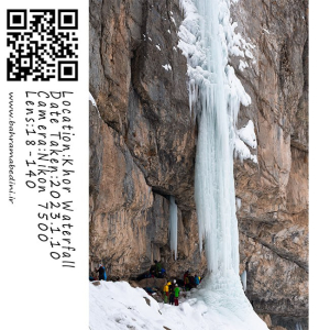
آبشار خور یکی از جاذبههای طبیعی زیبا در روستای خور، ایران است. این آبشار دیدنی به خاطر زیبایی آرامشبخش و سرسبزی اطرافش شناخته شده است. آبشار از صخرههای سنگی به پایین میریزد و به استخری شفاف در پایین میرسد، که محیطی آرام و تازهکننده ایجاد میکند. این منطقه در میان کوهنوردان و علاقهمندان به طبیعت که از مسیرهای دیدنی منتهی به آبشار لذت میبرند، محبوب است. بهترین زمان برای بازدید از این آبشار در فصل بهار و اوایل تابستان است که جریان آب در اوج خود قرار دارد و گیاهان اطراف در حال شکوفهدهی هستند.
به این عکس امتیاز دهید.
این عکس توسط بهرام عابدینی از تپه ها و طبیعت اطراف این منطقه گرفته شده است. برای خرید این عکس یا عکس های دیگر از طریق وبسایت یا تلفن با ما تماس بگیرید.
Khor Waterfall is a stunning natural attraction located in the village of Khor, Iran. This picturesque waterfall is known for its serene beauty and the lush greenery that surrounds it. The waterfall cascades down rocky cliffs into a clear pool below, creating a tranquil and refreshing environment. The area is popular among hikers and nature enthusiasts who enjoy the scenic trails leading to the waterfall. The best time to visit is during the spring and early summer when the water flow is at its peak, and the surrounding flora is in full bloom.
Please rate this picture.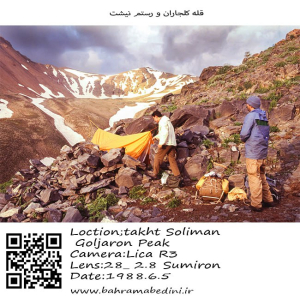
کوه کلجاران و رستم نیشت دو قله برجسته در توده تخت سلیمان در رشتهکوه البرز ایران هستند. کوه کلجاران با ارتفاع تقریبی ۴۴۳۱ متر (۱۴۵۳۷ فوت) به دلیل مسیرهای پیادهروی چالشبرانگیز و درههای مهآلود و سرسبز که تحت تأثیر دریای خزر نزدیک قرار دارند، شناخته شده است. پیادهروی به گردنه کلجاران مناظر خیرهکنندهای از قلهها و درههای اطراف ارائه میدهد.
رستم نیشت با ارتفاع تقریبی ۴۴۲۶ متر (۱۴۵۲۰ فوت)، دارای یک فلات کوچک مثلثی با سه قله نوکتیز و دامنههای شیبدار پوشیده از سنگریزه است که به شدت به دره سهزار میافتند. صعود به رستم نیشت اغلب از روستای ونداربن آغاز میشود و از پناهگاه سرچال عبور میکند، که مناظر خیرهکنندهای از قلههای هفتخان و یخچال هفتخان را ارائه میدهد.
هر دو کوه پیادهرویهای دشوار و مناظر دیدنی ارائه میدهند و مقصدهای پاداشبخش برای کوهنوردان با تجربه هستند.
به این عکس امتیاز دهید.
این عکس توسط بهرام عابدینی از تپه ها و طبیعت اطراف این منطقه گرفته شده است. برای خرید این عکس یا عکس های دیگر از طریق وبسایت یا تلفن با ما تماس بگیرید.
Kaljaran Mountain and Rostam Nisht are two prominent peaks in the Takhte Soleyman Massif of the Alborz mountain range in Iran. Kaljaran Mountain stands at approximately 4,431 meters (14,537 feet) and is known for its challenging hiking routes and lush, fog-filled valleys influenced by the nearby Caspian Sea. The hike to Kaljaran Pass offers stunning views of the surrounding peaks and valleys.
Rostam Nisht, with an elevation of around 4,426 meters (14,520 feet), features a small triangular plateau with three pointy summits and steep scree-covered western slopes. The climb to Rostam Nisht often starts from the village of Vandar Bon and passes through the Sar Chal Shelter, leading to breathtaking views of the Haft Khan Peaks and the Haft Khan Glacier.
Both mountains offer demanding hikes and spectacular scenery, making them rewarding destinations for experienced hikers.
Please rate this picture.
This picture is taken by Bahram Abedini. If you want to purchase this picture or any other around this area please contact us through website, email or phone.