آخرین عکس های طبیعت و مناظر ایران
بهرام عابدینی
آخرین عکس های طبیعت و مناظر ایران
آخرین عکس های طبیعت و مناظر ایران
بهرام عابدینی
بهرام عابدینی
Website Language

")
Farsi Description:
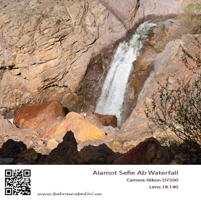
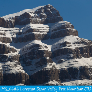
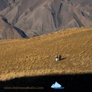
در استان لرستان، دره سزار یکی از زیباترین درههای کوهستانی است که در نزدیکی شهرستان دورود قرار دارد و رودخانه سزار با آب خروشان و طبیعت سرسبز از میان آن عبور میکند. در امتداد این منطقه، قله پریز با ارتفاعی حدود ۳۱۰۰ متر از جاذبههای مهم کوهنوردی به شمار میآید. این قله چشماندازهای گسترده، چشمههای زلال و غارهای طبیعی دارد و مسیر صعود آن از دورود آغاز میشود. ترکیب رودخانه سزار، صخرههای آهکی، پوشش گیاهی متنوع و هوای پاک، این منطقه را به مقصدی محبوب برای طبیعتگردان و کوهنوردان تبدیل کرده است.
به این عکس امتیاز دهید.
این عکس توسط بهرام عابدینی از تپه ها و طبیعت اطراف این منطقه گرفته شده است. برای خرید این عکس یا عکس های دیگر از طریق وبسایت یا تلفن با ما تماس بگیرید.
توضیحات انگلیسی:
In Lorestan Province, Sezar Valley is one of the most beautiful mountain gorges, located near Dorud, where the Sezar River flows through with rushing waters and lush scenery. Along this area, Pariz Peak, standing at about 3,100 meters, is a major attraction for mountaineers. The peak offers wide panoramic views, clear springs, and natural caves, with the main climbing route starting from Dorud. The combination of the Sezar River, limestone cliffs, diverse vegetation, and fresh mountain air makes this region a popular destination for nature lovers and hikers.
Please rate this picture.
This picture is taken by Bahram Abedini. If you want to purchase this picture or any other around this area please contact us through website, email or phone.
We sell pictures digitally in Large format and internationally through secure paypal payment in the US. Just let us know which picture you like through here: Contact-us
Farsi Description:
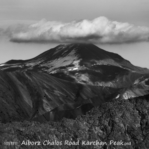
قلهٔ کرچان در رشتهکوه البرز مرکزی واقع شده و یکی از قلههای محبوب کوهنوردان است. این قله با ارتفاعی حدود ۳۹۰۰ متر (بسته به مسیر اندازهگیری) چشماندازی وسیع به دشت هراز، قلههای دماوند و منطقهٔ پلور دارد. مسیرهای صعود معمولاً از روستاهای نوا یا پلور آغاز میشود و به دلیل مناظر بکر، سکوت کوهستان و نزدیکی به تهران مقصدی جذاب برای صعود یکروزه یا دوروزه است.
به این عکس امتیاز دهید.
این عکس توسط بهرام عابدینی از تپه ها و طبیعت اطراف این منطقه گرفته شده است. برای خرید این عکس یا عکس های دیگر از طریق وبسایت یا تلفن با ما تماس بگیرید.
توضیحات انگلیسی:
Karchan Peak is located in the Central Alborz mountain range and is a popular destination for climbers. Standing at an elevation of about 3,900 m, it offers wide, breathtaking views of the Haraz plain, Mount Damavand, and the surrounding Plour region. The usual ascent routes start from the villages of Nava or Plour, making it an attractive choice for a one-day or two-day climb thanks to its pristine landscapes, peaceful mountain atmosphere, and convenient access from Tehran.
Please rate this picture.
This picture is taken by Bahram Abedini. If you want to purchase this picture or any other around this area please contact us through website, email or phone.
We sell pictures digitally in Large format and internationally through secure paypal payment in the US.
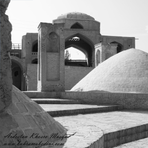
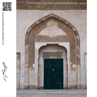
Farsi Description:
مسجد خسرو یکی از بناهای تاریخی شهر اردستان در استان اصفهان است که در دوره صفوی ساخته شده. این مسجد که به «مسجد آخوند» نیز معروف است، در محله راهمیان و خیابان دوازدهم بهمن قرار دارد و بهعنوان یکی از آثار ملی ایران به ثبت رسیده است.
به این عکس امتیاز دهید.
این عکس توسط بهرام عابدینی از تپه ها و طبیعت اطراف این منطقه گرفته شده است. برای خرید این عکس یا عکس های دیگر از طریق وبسایت یا تلفن با ما تماس بگیرید.
توضیحات انگلیسی:
Khosrow Mosque is a historical building located in the city of Ardestan, in Isfahan Province, Iran. It was built during the Safavid era and is also known as “Akhund Mosque.” Situated in the Rahmiyan neighborhood on 12th Bahman Street, it has been registered as a national heritage site of Iran.
Please rate this picture.
This picture is taken by Bahram Abedini. If you want to purchase this picture or any other around this area please contact us through website, email or phone.
We sell pictures digitally in Large format and internationally through secure paypal payment in the US.
Farsi Description:
قله پورا از جنوب به روستای کندر ، از شمال به روستای ابهرک و ارنگه ، از غرب به روستای آدران و از شرق بر روی خط الراس قلل چال ، سیوچال ، درزو و پشته بند محراب چشمه شاهی قله پهنه سار امتداد دارد مسیرهای صعود جاده قدیم کندور دره گلنا و آبشار نمرک و روستای ابهرک ارتغاع قله دوهزارو نصد متر است
به این عکس امتیاز دهید.
این عکس توسط بهرام عابدینی از تپه ها و طبیعت اطراف این منطقه گرفته شده است. برای خرید این عکس یا عکس های دیگر از طریق وبسایت یا تلفن با ما تماس بگیرید.
توضیحات انگلیسی:
Pura Peak is bordered to the south by the village of Kondor, to the north by the villages of Abharak and Arangeh, to the west by the village of Adran, and to the east along the ridge line of Chal, Sivchal, Darzu, and Pusht-e Band Mehrab Cheshmeh Shahi peaks, extending to Pahne Sar Peak. The ascent routes include the old Kondor Road, Golna Valley, Namrak Waterfall, and the village of Abharak. The peak's elevation is 2,900 meters.
Please rate this picture.
This picture is taken by Bahram Abedini. If you want to purchase this picture or any other around this area please contact us through website, email or phone.
We sell pictures digitally in Large format and internationally through secure paypal payment in the US.
Farsi Description:
قله لیچه به ارتفاع 2900 در استان البرز در شرق روستای کندور و در غرب روستای واریش تهران قرار دارد مسیرهای صعود روستای کندور و روستای واریش میباشد لیچه همجوار با کوه چشمه شاهی ودر ادامه یال به قله لیز و لیزان متصل می شود ارتفاع قله 2900 متر واین عکس از جاده قدیم کندور زیر قله پورا گرفته شده
به این عکس امتیاز دهید.
این عکس توسط بهرام عابدینی از تپه ها و طبیعت اطراف این منطقه گرفته شده است. برای خرید این عکس یا عکس های دیگر از طریق وبسایت یا تلفن با ما تماس بگیرید.
توضیحات انگلیسی:
"Liche Peak, with an elevation of 2900 meters, is located in Alborz Province, east of Kondor village and west of Varish village in Tehran. The ascent routes are from Kondor village and Varish village. Liche is adjacent to Cheshmeh Shahi mountain and continues along the ridge to connect to Liz and Lizan peaks. The elevation of the peak is 2900 meters, and this photo was taken from the old Kondor road below Pura Peak."
Please rate this picture.
This picture is taken by Bahram Abedini. If you want to purchase this picture or any other around this area please contact us through website, email or phone.
We sell pictures digitally in Large format and internationally through secure paypal payment in the US.
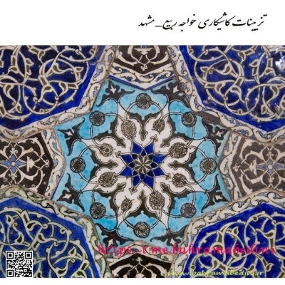
Farsi Description:
مسجد استاد و شاگرد یکی از مساجد تاریخی و معروف شهر اصفهان است. این مسجد در دوره صفویه ساخته شده و به دلیل معماری زیبا و کاشیکاریهای منحصر به فردش شهرت دارد. مسجد استاد و شاگرد به دو بخش اصلی تقسیم میشود: بخش استاد که بزرگتر و مجللتر است و بخش شاگرد که کوچکتر و سادهتر است. این تقسیمبندی نمادی از رابطه استاد و شاگرد در فرهنگ ایرانی است.
به این عکس امتیاز دهید.
این عکس توسط بهرام عابدینی از تپه ها و طبیعت اطراف این منطقه گرفته شده است. برای خرید این عکس یا عکس های دیگر از طریق وبسایت یا تلفن با ما تماس بگیرید.
توضیحات انگلیسی:
The Masjid-e Ustad va Shagird (Mosque of Master and Disciple) is one of the historic and renowned mosques in the city of Isfahan. Built during the Safavid era, this mosque is famous for its beautiful architecture and unique tile work. The mosque is divided into two main sections: the master's section, which is larger and more ornate, and the disciple's section, which is smaller and simpler. This division symbolizes the relationship between master and disciple in Iranian culture.
Please rate this picture.
This picture is taken by Bahram Abedini. If you want to purchase this picture or any other around this area please contact us through website, email or phone.
We sell pictures digitally in Large format and internationally through secure paypal payment in the US.
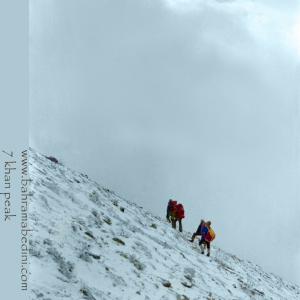
Farsi Description:
قله هفت خوان یکی از قلل زیبای رشتهکوه البرز غربی است که در نزدیکی روستای سپهسالار قرار دارد و ارتفاع آن به ۳۹۷۰ متر میرسد. در زمستان سال ۱۳۵۹، صعود به این قله به دلیل شرایط سخت آب و هوایی و برف سنگین، چالشی بزرگ برای کوهنوردان بود.
در آن سال، گروهی از کوهنوردان با تجهیزات محدود و بدون امکانات پیشرفته امروزی، تصمیم به صعود به قله هفت خوان گرفتند. مسیر صعود از روستای سپهسالار آغاز شد و کوهنوردان با عبور از یال جنوبی و گردنه خرگوش، به سمت قله حرکت کردند. شرایط سخت زمستانی، از جمله برف سنگین و بادهای شدید، این صعود را بسیار دشوار کرد.
با وجود این چالشها، کوهنوردان با تلاش و پشتکار فراوان توانستند به قله برسند و این صعود به عنوان یکی از دستاوردهای مهم کوهنوردی در آن زمان به شمار میرفت. این صعود نشاندهنده اراده و عزم راسخ کوهنوردان در مواجهه با شرایط سخت طبیعی بود.
به این عکس امتیاز دهید.
این عکس توسط بهرام عابدینی از تپه ها و طبیعت اطراف این منطقه گرفته شده است. برای خرید این عکس یا عکس های دیگر از طریق وبسایت یا تلفن با ما تماس بگیرید.
توضیحات انگلیسی:
Mount Haft Khān is one of the beautiful peaks of the western Alborz mountain range, located near the village of Sepahsalar, with an elevation of 3,970 meters (13,024.93 feet.). In the winter of 1980, climbing this peak was a significant challenge for mountaineers due to harsh weather conditions and heavy snowfall.
That year, a group of mountaineers, with limited equipment and without the advanced facilities available today, decided to climb Mount Haft Khān. The ascent route started from the village of Sepahsalar, and the climbers moved towards the peak by passing through the southern ridge and Kharghosh Pass. The harsh winter conditions, including heavy snow and strong winds, made this climb very difficult.
Despite these challenges, the mountaineers, with great effort and perseverance, managed to reach the summit. This climb was considered one of the significant achievements in mountaineering at that time. It demonstrated the determination and strong will of mountaineers in facing tough natural conditions.
Please rate this picture.
This picture is taken by Bahram Abedini. If you want to purchase this picture or any other around this area please contact us through website, email or phone.
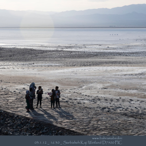
Farsi Description:
تالاب کجی نمکزار در نزدیکی نهبندان، خراسان جنوبی، با وسعت ۲۲۷۶۵ هکتار، زیستگاه پرندگان مهاجر و بومی متعددی است. این تالاب به دلیل املاح معدنی موجود در آب، خواص درمانی دارد و زیستگاه گونههای مختلف پستانداران نیز میباشد.
به این عکس امتیاز دهید.
این عکس توسط بهرام عابدینی از تپه ها و طبیعت اطراف این منطقه گرفته شده است. برای خرید این عکس یا عکس های دیگر از طریق وبسایت یا تلفن با ما تماس بگیرید.
توضیحات انگلیسی:
Kajeh Namakzar Wetland, located near Nehbandan in South Khorasan, spans 22,765 hectares and is a habitat for numerous migratory and native birds. The wetland's mineral-rich waters have therapeutic properties, and it is also home to various mammal species.
Please rate this picture.
This picture is taken by Bahram Abedini. If you want to purchase this picture or any other around this area please contact us through website, email or phone.
Farsi Description:
به این عکس امتیاز دهید.
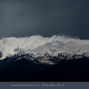
این عکس توسط بهرام عابدینی از تپه ها و طبیعت اطراف این منطقه گرفته شده است. برای خرید این عکس یا عکس های دیگر از طریق وبسایت یا تلفن با ما تماس بگیرید.
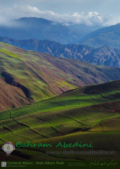
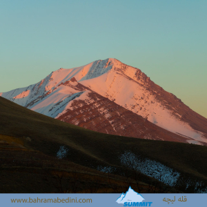
قله شاه البرز با ارتفاع ۴۱۷۰ متر، در مرز استانهای البرز و قزوین قرار دارد و مرز طبیعی بین دره طالقان و دره الموت است. این قله دارای پنج قله فرعی بالای ۴۰۰۰ متر است و مسیرهای صعود آن از روستاهای حسنجون، هرنج و سی چشمه در طالقان و جاده الموت انجام میشود. شاه البرز به دلیل چشماندازهای زیبا و طبیعت بکر، مقصد محبوبی برای کوهنوردان است.
توضیحات انگلیسی:
Please rate this picture.
This picture is taken by Bahram Abedini. If you want to purchase this picture or any other around this area please contact us through website, email or phone.
Shah Alborz Peak, standing at 4,170 meters, is located on the border of Alborz and Qazvin provinces, forming a natural boundary between Taleghan Valley and Alamut Valley. It has five subsidiary peaks over 4,000 meters. The ascent routes typically start from the villages of Hasanjoon, Haranj, and Si Cheshmeh in Taleghan, as well as from the Alamut road. Due to its beautiful landscapes and pristine nature, Shah Alborz is a popular destination for mountaineers.
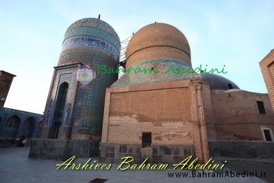
Farsi Description:
به این عکس امتیاز دهید.
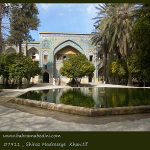
این عکس توسط بهرام عابدینی از تپه ها و طبیعت اطراف این منطقه گرفته شده است. برای خرید این عکس یا عکس های دیگر از طریق وبسایت یا تلفن با ما تماس بگیرید.
مدرسه خان در شیراز، یکی از بناهای تاریخی دوران صفویه است که به دستور اللهوردی خان گرجی در سال ۱۰۰۴ هجری قمری ساخته شد. این مدرسه به دلیل معماری زیبا و حضور ملاصدرا، فیلسوف بزرگ ایرانی، به عنوان مدرس، شهرت دارد. مدرسه خان دارای ۹۲ حجره، ۵ مدرس، ۱۲ راهرو و یک مسجد است و در خیابان لطفعلی خان زند قرار دارد. امروزه این مدرسه یکی از جاذبههای گردشگری شیراز محسوب میشود.
توضیحات انگلیسی:
Please rate this picture.
This picture is taken by Bahram Abedini. If you want to purchase this picture or any other around this area please contact us through website, email or phone.
Khan School in Shiraz is a historical building from the Safavid era, built by Allahverdi Khan in 1595. Known for its beautiful architecture and the presence of the great Iranian philosopher Mulla Sadra as a teacher, the school features 92 rooms, 5 lecture halls, 12 corridors, and a mosque. Located on Lotf Ali Khan Zand Street, it is now a popular tourist attraction in Shiraz.