Photogram
Selling the latest photos of Iran by Bahram Abedini
Photogram
Photogram
Latest photos by Bahram Abedini
Latest photos of Iran by Bahram Abedini
Website Language

")
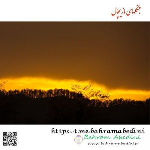
مازیچال، جزو جنگلهای هیرکانی در مازندران است. این منطقه برای سفر در تمامی فصول میتواند مقصد خوبی محسوب شود. از جمله جاذبه های این نوع سفر میتوان به پیاده روی در جنگل و لذت بردن از مناظر بکر و زیبای آن نام برد. مهمترین گونهی گیاهی این منطقه نوعی بلوط است که تنها در این جنگل دیده میشود. در زبان محلی بلوط را «مازو» و به گودال «چال» میخوانند، به دلیل انبوه درختان بلوط در این منطقه، آن را «مازیچال» نام نهادند که به معنای گودال بلوط است.
Mazichal is part of the Hirkani forests in Mazandaran. This area can be a good destination for travel in all seasons. Among the attractions of this kind of trip, you can walk in the woods and enjoy the beautiful scenery. The most important plant species in this area is an oak tree that is only visible in this forest. In the local language, the oak is called "Mazo" and the valley is called "Chal" so due to the massive number of oak trees in the area, it is called "Mazichal", which means the oak valley.
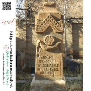
کلیسای مریم ننه در محلهٔ مارالان، مابین کوچه خان و ارمنی دونن و در محل قبرستان ارمنی باغی در کوچهای روبروی روس باغی باغ روسها - ملک جمهوری فدراتیو روسیه فعلی قرار دارد. این کلیسا در زمان قاجار ساخته شدهاست. این کوچکترین کلیسای تبریز است در شهر تبریز دارای چها کلیسا ویک خلیفه گری است کلیسای شوقوقات _ مریم مقدس _مریم ننه _ سرکیس از جمله مکانهای مذهبی ارامنه تبریز است
The Maryna Naneh Church in the Maralan neighborhood, between Kuchak Khan and Armenian Dunan, and at the site of the Armenian Baghi Cemetery, is located in the foothills of the Russian Orthodox Church of the Russian Garden, the property of the current federal republic of Russia. This church was built in Qajar period. This is Tabriz's smallest church in the city of Tabriz. It has a chapel and a caliphate. The Church of the Blessed Virgin Mary _Marim Neda-Sarikis is one of the Armenian religious places in Tabriz.

پرورش و فروش جوجه اردک در شهرستان فومن وشهرهای شمالی رسمی عادی است که از تخم وگوشت آن استفاده می کنند مشتری این اردکها شالیکاران هستند که بهصورت فلهای جوجه اردکها را خریداری میکنند و پسازاینکه شالیهای برنج جمع شد،
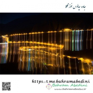
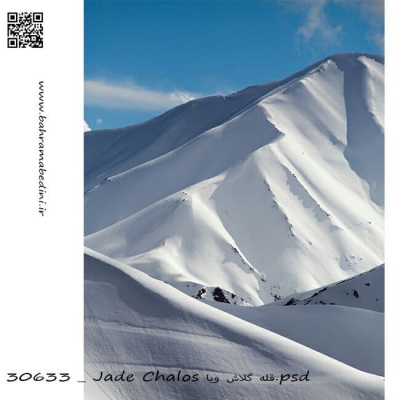
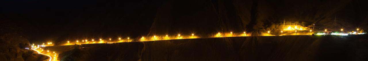
جاده چالوس یا جادهی پنچاه و نه جاده ای که استان البرز را به استان مازندران متصل می کند. دارای زیباترین منظره ها، کوهها، آبشارها و دریاچهها میباشد. از مهمترین این جاذبههای طبیعی میتوان به کوهای تخت سلیمان، علم کوه و آزاد کوه و.... آبشار اندرس و کمجل، دریاچه ولشت، حصار چال و بسیاری دیگر از جاذبه های زیبا و دیدنی اشاره نمود که از طریق این جاده قابل دستیابی هستند.
Chalous road or a Fifty Five road connects Alborz province to Mazandaran province. It has the most beautiful views, mountains, waterfalls, and lakes. The most important of these natural attractions can be found on the plains of Takht-e-Soleiman, Kalam-e-Kuh, and Azad Kuh ... Anders and Kahjel waterfall, Volhshest Lake, Hesar Chal and many other beautiful and spectacular attractions that can be reached through this road.
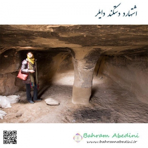
منطقه اشتهارد در جنوب کرج دارای جذابیتهای فراوانی است از جمله خانه های سنگی دستکند که تا هزارو چهار صد سال پیش در آنجا زندگی می کردند و قدمت آن دو هزار سال تخمین زده شده است. به علت کمبود منابع آبی در این مکان ، منطقه تخلیه شده است. از جمله جذابیتهای اشتهارد می توان به تالاب و غار نمکی و تپه های رنگی اشاره کرد.
The Eshtehard area in the south of Karaj has many attractions, including rocky houses that were habituated until fourteen hundred years ago and are estimated to be two thousand years old. Due to lack of water resources in this place, the area has been evacuated. Among the attractions of Eshtehard, you can mention the salt lake and cave and the colorful hills.
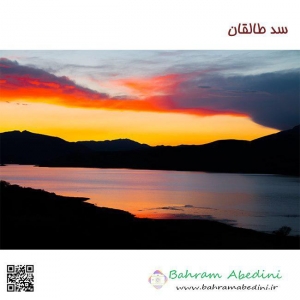
به منظور انتقال آب طالقان به دشت قزوین، در سال هزارو سیصدو چهل و هشت ساخت سد انحرافی سنگبان در طالقان و تونل انتقال آب به طول نه کیلومتر تا زیاران و سد انحرافی زیاران و مجموعه کانالهای آبیاری دشت قزوین آغاز شد . در همان سالها، مطالعاتی پیرامون سد مخزنی جهت ذخیره سیلابهای بهارهٔ رود طالقان نیز انجام شد در فروردین سال هشتادو یک عملیات ساخت سد مخزنی طالقان آغاز شد و در سال هشتادو پنچ به بهرهبرداری رسید. مساحت دریاچه دوازده کیلومتر مربع و طول تاج هزارو صد متر و بستر آن از جنس خاکی و رسی میباشد
In order to transfer Taleghan's water to Qazvin plain, in the year 1348, construction of the Sangban dam was done in Taleghan and the tunnel was transmitted to the nine kilometers to the shafts and the diverging dam of Ziaran and a collection of irrigation channels in Qazvin plain. In the same years, studies on reservoir were also carried out to store the Taleghan spring floods. In April of 2014, a Taleghan reservoir construction began and started to be exploited in the 1980s. The area of the lake is twelve square kilometers and the length of the crown is one hundred and thirty meters and the base is of soil and clay.
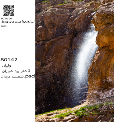
منطقه ساوجبلاغ شمالی دارای آب وهوای خنک در تابستان و در زمستان سرد روستاهای برقان اغشت سنج کردان سیرود ولیان همگی در کوهپایه های البرز مرکزی قرار دارد ودارای کوهایی به ارتفاع سه هزار تا چهار هزار متر که بلندترین آن ناز کهار به ارتفاع جهارو صدو پنچاه متر می باشد همچنین دارای آبشارهای فراوان از قبیل آبشارهای سنج -وارش کرور - جوزدره - سیرود - ولیان - سوته دره فشند والا دیگر این عکس در بهمن ماه نودو شش از روی گوهای دوروان گرفته شده است
The northern Savojbolagh region has cool weathers in the summer, and is cold in winters. the villages of Baraghan, Senj, Kordan, Sirood, and Valyan are all located in the foothills of the central Alborz, with a quay of three thousand to four thousand meters, the tallest of which is cute with a height of about one hundred and five feet Also, there are many waterfalls such as waterfalls of the mosque - Korur - Josedra - Syroud - Valian - Suet Valley of Fashand Valah. The other image was taken in February of the ninety sixth of Dowwan's circle
منطقه کوهستانی طالقان یکی از بی نظیرترین درهها و مناطق کوهستانی ایران واقع در منطقه البرز غربی است که سراسر آن را از شرق به غرب رودخانه خروشان طالقان رود یا به عبارتی شاهرود طی می کند و با عبور از دریاچه سد طالقان به رودخانه الموت و سپس به دریاچه سد سپیدرود میپیوندد
The Taleghan mountainous region is one of the most unique valleys and mountainous regions of Iran located in the western Alborz region, which runs across it from east to west to the Taleghan River (Shahrud), passing through the lake of Taleghan to the Alamut River and then to Lake Sepidrud Dam.
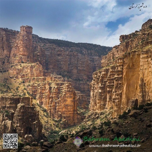
شیرز دره ای در کوهدشت لرستان مرز بین سه استان کرمانشاه لرستان وکردستان دره ای با صخرهای سر به فلک کشیده رودخانه با آب زلال آبشار غار و برج سنگی معروف یکی از بکر ترین مناطق ایران است مردم کوهدشت بیشتر دامداری وکشاورزی می کنند ولی اهالی سیاه چادر ها به کار دامداری مشغول هستند و بسیار مهمانواز.............. این عکس در بهار 95 به ثبت رسیده است
Shirz valley in Kohdasht Lorestan border between the three provinces of Kermanshah Lorestan and Kurdistan with a cliff-climbed river with a clear water of the cascade of the Qar and a famous stone tower is one of the most pristine regions of Iran. Kowhdasht people are most into agriculture, but the people of black tents (gypsies) are busy with livestock and are very hospitable .............. This photo was recorded in the spring of 2016.