گردشگری، ایران گردی، مدیریت جهانگردی
گردشگری، ایران گردی، مدیریت جهانگردی
به قلم شهرزاد عابدینی
گردشگری، ایران گردی، مدیریت جهانگردی
به سردبیری شهرزاد عابدینی
به سردبیری شهرزاد عابدینی
Website Language

")


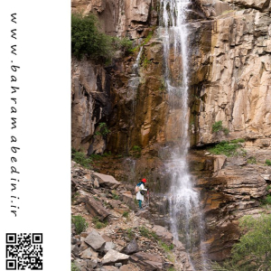
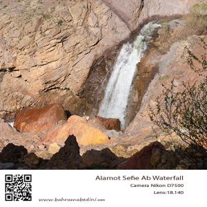
آبشار ورچور در استان قزوین به ارتفاع 30 متر در روستای رزجرد و آب آن از کوه تومون چال تامین می گردد# Varchor ورچر به زبان تاتی یعنی کنار آبشار ور به معنای کنار چر هم به معنای شر یا سرازیرشدن یا همان آبشار.#ورچر# آبشار#قزوین# رزجرد#کوه پیمائی3
به این عکس امتیاز دهید.
این عکس توسط بهرام عابدینی از تپه ها و طبیعت اطراف این منطقه گرفته شده است. برای خرید این عکس یا عکس های دیگر از طریق وبسایت یا تلفن با ما تماس بگیرید.
English description:
Varchor Waterfall in Qazvin Province, Iran, is a stunning natural attraction standing over 30 meters tall. Located near Razjerd village, it is surrounded by lush greenery and massive rocks, especially beautiful in spring. The area is home to various plant species and is a popular spot for locals, nature enthusiasts, and hikers. The journey to the waterfall involves a hike of about two hours, which can be shortened with a motorcycle or mountain bike.
Please rate this picture.
This picture is taken by Bahram Abedini. If you want to purchase this picture or any other around this area please contact us through website, email or phone.
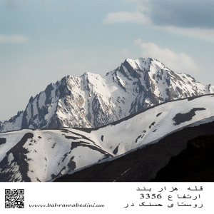
قله هزار بند در رشتهکوه البرز مرکزی و استان البرز قرار دارد. این قله با ارتفاع ۳۳۵۰ متر، به دلیل ساختار سنگی و صخرهای خود، نیاز به تجربه نسبی در کوهنوردی دارد. مسیر اصلی صعود از روستای حسنکدر شروع میشود و حدود ۵.۵ ساعت طول میکشد.
به این عکس امتیاز دهید.
این عکس توسط بهرام عابدینی از تپه ها و طبیعت اطراف این منطقه گرفته شده است. برای خرید این عکس یا عکس های دیگر از طریق وبسایت یا تلفن با ما تماس بگیرید.
Mount Hezarband is located in the central Alborz mountain range in Alborz Province. This peak, standing at 3,350 meters, is known for its rocky and rugged terrain, requiring some mountaineering experience. The main ascent route starts from the village of Hasanakdar and takes about 5.5 hours to reach the summit.
Literal translation of Hezarband means thousand shackles .
Please rate this picture.
This picture is taken by Bahram Abedini. If you want to purchase this picture or any other around this area please contact us through website, email or phone.
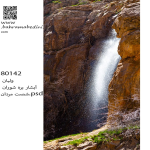
آبشار بره شوران که در رشتهکوههای البرز واقع شده، یکی از جاذبههای طبیعی زیبا است که در میان پوشش گیاهی انبوه و زمینهای ناهموار قرار دارد. این آبشار از ارتفاع قابل توجهی فرو میریزد و منظرهای خیرهکننده و صدای آرامشبخش آب جاری را ایجاد میکند. منطقه اطراف آبشار دارای تنوع زیستی غنی است و هوای خنک و تازهای دارد که آن را به مکانی ایدهآل برای یک سفر روزانه آرامشبخش تبدیل میکند. دسترسی به این آبشار معمولاً شامل یک پیادهروی از طریق مسیرهای دیدنی با چشماندازهای فوقالعاده از کوههای البرز است.
به این عکس امتیاز دهید.
این عکس توسط بهرام عابدینی از تپه ها و طبیعت اطراف این منطقه گرفته شده است. برای خرید این عکس یا عکس های دیگر از طریق وبسایت یا تلفن با ما تماس بگیرید.
English description:
Bareh Shooran Waterfall, located in the Alborz Mountains, is a beautiful natural attraction surrounded by lush greenery and rugged terrain. The waterfall cascades from a significant height, creating a mesmerizing sight and a soothing sound. The area is rich in biodiversity and offers a cool, refreshing atmosphere, making it ideal for a relaxing day trip. Access involves a scenic hike through trails with breathtaking views of the mountains.
Please rate this picture.
This picture is taken by Bahram Abedini. If you want to purchase this picture or any other around this area please contact us through website, email or phone.
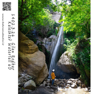
آبشار کلشتر در جنوب غربی شهرستان رودبار و در روستای کلشتر واقع شده است. این آبشار با ارتفاع بیش از ۲۰ متر در میان جنگلهای انبوه قرار دارد و یکی از دیدنیترین آبشارهای گیلان است. برای رسیدن به آبشار، باید از جادههای محلی و جنگلی عبور کرده و حدود ۲۰ تا ۳۰ دقیقه پیادهروی کنید. بهترین زمان برای بازدید فصل بهار و تابستان است که هوا معتدل و طبیعت سرسبز است.
به این عکس امتیاز دهید.
این عکس توسط بهرام عابدینی از تپه ها و طبیعت اطراف این منطقه گرفته شده است. برای خرید این عکس یا عکس های دیگر از طریق وبسایت یا تلفن با ما تماس بگیرید.
English description:
Kalashter Waterfall is located in the southwest of Rudbar County, in the village of Kalashter. This waterfall, with a height of over 20 meters, is nestled among dense forests and is one of the most scenic waterfalls in Gilan Province. To reach the waterfall, you need to travel through local and forest roads and then walk for about 20 to 30 minutes. The best time to visit is during spring and summer when the weather is mild and the nature is lush and green.
Please rate this picture.
This picture is taken by Bahram Abedini. If you want to purchase this picture or any other around this area please contact us through website, email or phone.
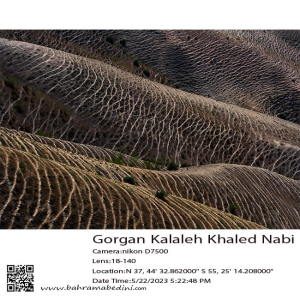
گورستان خالد نبی در شهرستان کلاله، استان گلستان، یکی از مکانهای تاریخی و اسرارآمیز ایران است. این گورستان در ارتفاعات کوه گوگجه داغ واقع شده و به دلیل سنگقبرهای منحصر به فرد و طراحیهای خاص، شهرت دارد. مقبره خالد نبی و آرامگاههای همراهانش، عالم بابا و چوپان آتا، در این مکان قرار دارند. بهترین زمان برای بازدید از این گورستان فصل بهار و اوایل تابستان است.
به عکس امتیاز دهید.
این عکس توسط بهرام عابدینی از تپه ها و طبیعت اطراف این منطقه گرفته شده است. برای خرید این عکس یا عکس های دیگر از طریق وبسایت یا تلفن با ما تماس بگیرید.
English description:
Khaled Nabi Cemetery is a historical site in Kalaleh County, Golestan Province, Iran, named after the prophet Khaled bin Sinan. Located on the Gokjeh Dagh mountain, it offers stunning views and features unique, ancient tombstones with intriguing designs. The site includes the shrine of Khaled Nabi and the tombs of his companions. The best time to visit is during spring and early summer when the weather is mild and the landscape is lush.
Please rate this picture.
This picture is taken by Bahram Abedini. If you want to purchase this picture or any other around this area please contact us through website, email or phone.
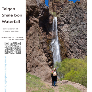
آبشار شاله بن یکی از زیباترین و بکرترین آبشارهای منطقه طالقان در استان البرز ایران است. این آبشار از قلل خسبان سرچشمه میگیرد و سپس به رودخانه خسبان رود میریزد. آبشار شاله بن در غرب روستای بزج و در حدود ۱۰ کیلومتری شمال شهرک طالقان واقع شده است.
مناظر طبیعی اطراف این آبشار بسیار چشمنواز و دلانگیز است و به عنوان یکی از جاذبههای گردشگری محبوب در طالقان شناخته میشود. طبیعت بکر و ناب این منطقه، آن را به مکانی ایدهآل برای علاقهمندان به طبیعتگردی و عکاسی تبدیل کرده است.
به این عکس امتیاز دهید.
این عکس توسط بهرام عابدینی از تپه ها و طبیعت اطراف این منطقه گرفته شده است. برای خرید این عکس یا عکس های دیگر از طریق وبسایت یا تلفن با ما تماس بگیرید.
English description:
Shaleh Bon Waterfall is one of the most beautiful and pristine waterfalls in the Taleghan region of Alborz Province, Iran. This waterfall originates from the Khesban peaks and flows into the Khesban River. It is located to the west of the village of Bozaj and about 10 kilometers north of Taleghan town.
The waterfall is composed of three tiers and has a height of approximately 25 meters. The access route to the waterfall passes through the villages of Khesban and Bozaj, both of which feature stunning natural landscapes and lush gardens. Along the way, you can also visit the Bozaj Cave, which has a depth of about 25 meters.
The best time to visit Shaleh Bon Waterfall is during the spring and summer seasons when the waterfall is more voluminous and the weather is milder. In winter, due to snow and ice, visiting this area can be challenging.
Please rate this picture.
This picture is taken by Bahram Abedini. If you want to purchase this picture or any other around this area please contact us through website, email or phone.
آبشار سفیدآب، واقع در استان لرستان ایران، یکی از جاذبههای طبیعی خیرهکننده است که در حدود ۵۰ کیلومتری جنوب شرقی الیگودرز قرار دارد. این آبشار با ارتفاع ۷۰ متر، به دلیل جریان قوی و مه سفید رنگی که ایجاد میکند، معروف است و در قلب رشتهکوههای زاگرس قرار دارد. منطقه اطراف آبشار دارای تنوع زیستی غنی است و شامل گونههای مختلف گیاهی و حیات وحش میشود. آبشار سفیدآب در هر فصل تجربهای منحصر به فرد ارائه میدهد، از جریان کامل در بهار تا تبدیل شدن به یک سرزمین عجایب یخزده در زمستان. این آبشار از طریق جادههای کوهستانی و یک پیادهروی متوسط قابل دسترسی است و مناظر خیرهکننده و محیطی آرام برای بازدیدکنندگان فراهم میکند.
به این عکس امتیاز دهید.
این عکس توسط بهرام عابدینی از تپه ها و طبیعت اطراف این منطقه گرفته شده است. برای خرید این عکس یا عکس های دیگر از طریق وبسایت یا تلفن با ما تماس بگیرید.
Sefid Aab Waterfall, located in Lorestan Province, Iran, is a stunning natural attraction about 50 kilometers southeast of Aligudarz. This 70-meter-high waterfall, known for its powerful flow and white mist, is nestled in the Zagros Mountains. The area is rich in biodiversity, featuring various plant species and wildlife. The waterfall offers a unique experience in each season, from the full flow in spring to a frozen wonderland in winter. Accessible via mountain roads and a moderate hike, it provides breathtaking scenery and a serene environment for visitors.
Please rate this picture.
This picture is taken by Bahram Abedini. If you want to purchase this picture or any other around this area please contact us through website, email or phone.
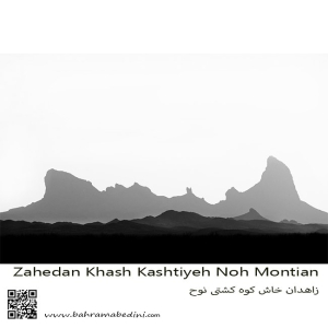
کوه تفتان، که به نام کوه کشتی نوح نیز شناخته میشود، یکی از مهمترین و مرتفعترین کوههای جنوب شرقی ایران است. این کوه در نزدیکی شهرستان خاش و در فاصله حدود ۱۰۰ کیلومتری از زاهدان قرار دارد. تفتان با ارتفاع ۳۹۴۱ متر از سطح دریا، به عنوان یک کوه آتشفشانی فعال شناخته میشود و دارای چهار قله اصلی به نامهای چهل تن، مادرکوه، صبح کوه و نرکوه است.
ویژگیهای برجسته کوه تفتان:
فعالیتهای آتشفشانی: تفتان به دلیل فعالیتهای آتشفشانی خود مشهور است و از دهانههای آن گازهای گوگردی به طور مداوم خارج میشود.
چشمههای آب معدنی: در اطراف کوه، چشمههای آب معدنی متعددی وجود دارد که به دلیل خواص درمانی خود، مورد توجه گردشگران و محلیها قرار گرفتهاند.
طبیعت بکر: مناظر طبیعی زیبا و بکر این منطقه، شامل پوشش گیاهی متنوع و حیات وحش غنی، این کوه را به مقصدی محبوب برای طبیعتگردان و کوهنوردان تبدیل کرده است.
مسیرهای کوهنوردی: مسیرهای مختلفی برای صعود به قلههای تفتان وجود دارد که هر کدام چالشها و زیباییهای خاص خود را دارند
به این عکس امتیاز دهید.
این عکس توسط بهرام عابدینی از تپه ها و طبیعت اطراف این منطقه گرفته شده است. برای خرید این عکس یا عکس های دیگر از طریق وبسایت یا تلفن با ما تماس بگیرید.
Mount Taftan, also known as Noah’s Ark Mountain, is one of the most significant and tallest mountains in southeastern Iran. Located near the city of Khash and about 100 kilometers from Zahedan, Taftan stands at an elevation of 3,941 meters above sea level and is known as an active volcanic mountain. It features four main peaks: Chehel Tan, Madar Kuh, Sobh Kuh, and Nar Kuh, from which sulfur gases continuously emit.
قله جوپار، که به قله سه شاخ بزرگ نیز معروف است، یکی از مرتفعترین و فنیترین قلل ایران است. این قله در رشتهکوه جوپار در استان کرمان قرار دارد و ارتفاع آن به ۴۱۳۵ متر میرسد¹². کوهستان جوپار به دلیل دیوارههای بلند، تیغههای سوزنی شکل، و برفچالهای عظیم، به ویژه در فصل زمستان، یکی از چالشبرانگیزترین مقاصد کوهنوردی در ایران محسوب میشود¹².
شهر جوپار نیز در بخش ماهان شهرستان کرمان واقع شده و به دلیل آب و هوای خوب و طبیعت زیبا، مقصدی محبوب برای گردشگران است
به این عکس امتیاز دهید.
این عکس توسط بهرام عابدینی از تپه ها و طبیعت اطراف این منطقه گرفته شده است. برای خرید این عکس یا عکس های دیگر از طریق وبسایت یا تلفن با ما تماس بگیرید.
Choopar Mountain, also known as Joopar Mountain, is one of the most prominent and challenging peaks in Iran. Located in the southeastern part of Kerman Province, this mountain is part of the Joopar mountain range, which stretches approximately 22 kilometers in length and 10 kilometers in width.
The highest peak in this range, known as the "Three Horns" or "Seh Shakh Bozorg," reaches an elevation of 4,135 meters. The mountain is renowned for its steep cliffs, needle-like ridges, and large snowfields, making it a popular destination for experienced climbers and mountaineers. Even in summer, snow can often be found on its highest peaks.
The area is also rich in biodiversity, with various medicinal plants such as thyme and black cumin, as well as wildlife including wolves, foxes, and mountain goats⁴⁵. The scenic beauty and challenging terrain of Choopar Mountain make it a significant attraction for nature enthusiasts and adventure seekers alike.
Please rate this picture.
This picture is taken by Bahram Abedini. If you want to purchase this picture or any other around this area please contact us through website, email or phone.
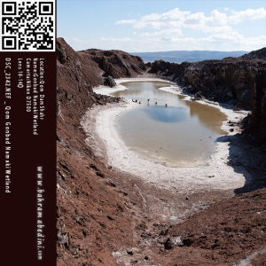
گنبد نمکی قم، که به نام گنبد نمکی طغرود نیز شناخته میشود، یکی از جاذبههای طبیعی و منحصر به فرد استان قم است. این گنبد در ۱۵ کیلومتری جاده قم به سمت جعفریه قرار دارد و به دلیل تقارن و وجود دریاچهای کوچک در دل خود، تنها گنبد نمکی متقارن جهان محسوب میشود.
این گنبد نمکی با قدمتی حدود ۶۰ میلیون سال، از بلورهای نمک به شکل تیغههای کنگرهدار تشکیل شده که مناظر زیبایی را خلق کردهاند. دریاچه نمکی درون گنبد، پس از بارشهای فصلی و تبخیر آبهای شور، به لایههای ضخیمی از نمک تبدیل میشود که تا ارتفاع نیم متر نیز میرسد.
این منطقه به دلیل زیباییهای طبیعی و خواص درمانی آب نمک، مقصدی محبوب برای گردشگران و علاقهمندان به ژئوتوریسم است
به این عکس امتیاز دهید.
این عکس توسط بهرام عابدینی از تپه ها و طبیعت اطراف این منطقه گرفته شده است. برای خرید این عکس یا عکس های دیگر از طریق وبسایت یا تلفن با ما تماس بگیرید.
Gonbad Namaki Ghom, also known as the Qom Salt Dome, is a fascinating natural attraction located about 20 kilometers northwest of Qom city on the Qom-Jaafrieh axis. This salt dome is renowned for its unique geological formations and stunning landscapes, making it one of the largest and most beautiful salt domes in Iran⁴.
The dome, which is around 60 million years old, features impressive salt crystals that form intricate patterns and shapes. During the rainy seasons, a small salt lake forms within the dome, creating a striking contrast with the surrounding arid landscape⁴. This lake, however, is not permanent and often dries up during the hotter months⁴.
Gonbad Namaki Ghom is a popular destination for tourists and geotourism enthusiasts, who visit to admire its natural beauty and explore its therapeutic salt properties⁴.
Please rate this picture.
This picture is taken by Bahram Abedini. If you want to purchase this picture or any other around this area please contact us through website, email or phone.