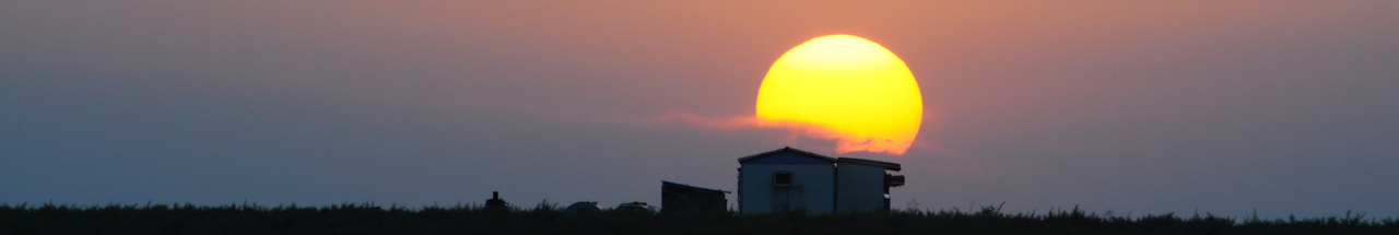
آخرین عکس های طبیعت و مناظر ایران
بهرام عابدینی
آخرین عکس های طبیعت و مناظر ایران
آخرین عکس های طبیعت و مناظر ایران
بهرام عابدینی
بهرام عابدینی
Website Language

")
Farsi Description:
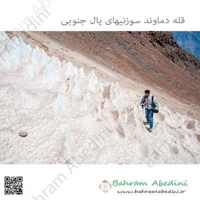
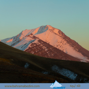
در استان لرستان، دره سزار یکی از زیباترین درههای کوهستانی است که در نزدیکی شهرستان دورود قرار دارد و رودخانه سزار با آب خروشان و طبیعت سرسبز از میان آن عبور میکند. در امتداد این منطقه، قله پریز با ارتفاعی حدود ۳۱۰۰ متر از جاذبههای مهم کوهنوردی به شمار میآید. این قله چشماندازهای گسترده، چشمههای زلال و غارهای طبیعی دارد و مسیر صعود آن از دورود آغاز میشود. ترکیب رودخانه سزار، صخرههای آهکی، پوشش گیاهی متنوع و هوای پاک، این منطقه را به مقصدی محبوب برای طبیعتگردان و کوهنوردان تبدیل کرده است.
به این عکس امتیاز دهید.
این عکس توسط بهرام عابدینی از تپه ها و طبیعت اطراف این منطقه گرفته شده است. برای خرید این عکس یا عکس های دیگر از طریق وبسایت یا تلفن با ما تماس بگیرید.
توضیحات انگلیسی:
In Lorestan Province, Sezar Valley is one of the most beautiful mountain gorges, located near Dorud, where the Sezar River flows through with rushing waters and lush scenery. Along this area, Pariz Peak, standing at about 3,100 meters, is a major attraction for mountaineers. The peak offers wide panoramic views, clear springs, and natural caves, with the main climbing route starting from Dorud. The combination of the Sezar River, limestone cliffs, diverse vegetation, and fresh mountain air makes this region a popular destination for nature lovers and hikers.
Please rate this picture.
This picture is taken by Bahram Abedini. If you want to purchase this picture or any other around this area please contact us through website, email or phone.
We sell pictures digitally in Large format and internationally through secure paypal payment in the US. Just let us know which picture you like through here: Contact-us
Farsi Description:
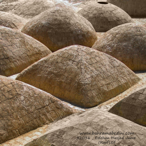
آتشکده اسپاخو بنایی تاریخی از دوره ساسانی است که در روستای اسپاخو در استان خراسان شمالی قرار دارد. این آتشکده با معماری سنگی و گنبدی شکل، دارای سه ورودی و ایوانی بلند در ضلع شرقی است. در گذشته برای نیایش زرتشتیان و نگهداری آتش مقدس استفاده میشد. این بنا یکی از قدیمیترین آثار تاریخی منطقه است و در فهرست آثار ملی ایران ثبت شده است.
به این عکس امتیاز دهید.
این عکس توسط بهرام عابدینی از تپه ها و طبیعت اطراف این منطقه گرفته شده است. برای خرید این عکس یا عکس های دیگر از طریق وبسایت یا تلفن با ما تماس بگیرید.
توضیحات انگلیسی:
The Espakho Fire Temple is a historical structure from the Sassanid era, located in the village of Espakho in North Khorasan Province, Iran. Built with stone and featuring a domed roof, the temple has three entrances and a tall eastern portico. It was used by Zoroastrians for worship and to preserve sacred fire. This temple is one of the oldest surviving monuments in the region and is listed as a national heritage site of Iran.
Please rate this picture.
This picture is taken by Bahram Abedini. If you want to purchase this picture or any other around this area please contact us through website, email or phone.
We sell pictures digitally in Large format and internationally through secure paypal payment in the US.
Farsi Description:
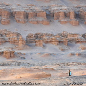
کویر لوت، که به عنوان دشت لوت نیز شناخته میشود، یک بیابان نمکی وسیع در جنوب شرقی ایران است. این یکی از گرمترین و خشکترین مکانهای زمین است که دمای سطح آن به شدت بالا میرسد. این بیابان حدود ۵۱٬۸۰۰ کیلومتر مربع را پوشش میدهد و دارای ویژگیهای زمینشناسی منحصر به فردی مانند یاردانگهای عظیم، بیابانهای سنگی گسترده و برخی از بلندترین تپههای شنی جهان است. این منطقه بادهای قوی را تجربه میکند که چشمانداز دراماتیک آن را شکل میدهند. در سال ۲۰۱۶، بیابان لوت به عنوان یک سایت میراث جهانی یونسکو به دلیل زیبایی طبیعی و اهمیت زمینشناسی آن شناخته شد.
به این عکس امتیاز دهید.
این عکس توسط بهرام عابدینی از تپه ها و طبیعت اطراف این منطقه گرفته شده است. برای خرید این عکس یا عکس های دیگر از طریق وبسایت یا تلفن با ما تماس بگیرید.
توضیحات انگلیسی:
The Lut Desert, also known as Dasht-e Lut, or Kavir_e Lut is a vast salt desert in southeastern Iran. It is one of the hottest and driest places on Earth, with surface temperatures reaching extreme highs. Covering about 51,800 square kilometers, it features unique geological formations like massive yardangs, extensive stony deserts, and some of the world's tallest sand dunes. The region experiences strong winds that shape its dramatic landscape. In 2016, the Lut Desert was recognized as a UNESCO World Heritage Site for its natural beauty and geological significance.
Please rate this picture.
This picture is taken by Bahram Abedini. If you want to purchase this picture or any other around this area please contact us through website, email or phone.
We sell pictures digitally in Large format and internationally through secure paypal payment in the US.
Farsi Description:
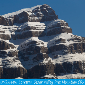
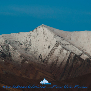
قله منا ر و گلوی به ارتفاع تقریبی سه وهزارو پانصد متر در شمال روستای واریان وجنوب شرقی روستای مورودقرار دارد این دوقله در خطالراس سیاه سنگ منار و گلوی و گلو سربند واقع است راه صعود به قله بیشتر از روستای مورود است آبشار های که از قله ها سرازیر می شود یکی آبشا ر چهار صد تنور در جنوب و آبشار رفک در شمال این کوه قرار دارد.
به این عکس امتیاز دهید.
این عکس توسط بهرام عابدینی از تپه ها و طبیعت اطراف این منطقه گرفته شده است. برای خرید این عکس یا عکس های دیگر از طریق وبسایت یا تلفن با ما تماس بگیرید.
توضیحات انگلیسی:
Please rate this picture.
The peaks of Manar and Golou, with an approximate height of 3,500 meters, are located north of the village of Varyan and southeast of the village of Moroud. These two peaks are situated on the ridge of Siah Sang Manar and Golou and Golou Sarband. The main route to ascend the peaks is from the village of Moroud. The waterfalls that flow from the peaks include the Four Hundred Tanur waterfall in the south and the Rafak waterfall in the north of this mountain."
This picture is taken by Bahram Abedini. If you want to purchase this picture or any other around this area please contact us through website, email or phone.
We sell pictures digitally in Large format and internationally through secure paypal payment in the US.
Farsi Description:
قله پورا از جنوب به روستای کندر ، از شمال به روستای ابهرک و ارنگه ، از غرب به روستای آدران و از شرق بر روی خط الراس قلل چال ، سیوچال ، درزو و پشته بند محراب چشمه شاهی قله پهنه سار امتداد دارد مسیرهای صعود جاده قدیم کندور دره گلنا و آبشار نمرک و روستای ابهرک ارتغاع قله دوهزارو نصد متر است
به این عکس امتیاز دهید.
این عکس توسط بهرام عابدینی از تپه ها و طبیعت اطراف این منطقه گرفته شده است. برای خرید این عکس یا عکس های دیگر از طریق وبسایت یا تلفن با ما تماس بگیرید.
توضیحات انگلیسی:
Pura Peak is bordered to the south by the village of Kondor, to the north by the villages of Abharak and Arangeh, to the west by the village of Adran, and to the east along the ridge line of Chal, Sivchal, Darzu, and Pusht-e Band Mehrab Cheshmeh Shahi peaks, extending to Pahne Sar Peak. The ascent routes include the old Kondor Road, Golna Valley, Namrak Waterfall, and the village of Abharak. The peak's elevation is 2,900 meters.
Please rate this picture.
This picture is taken by Bahram Abedini. If you want to purchase this picture or any other around this area please contact us through website, email or phone.
We sell pictures digitally in Large format and internationally through secure paypal payment in the US.
Farsi Description:
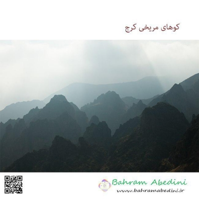
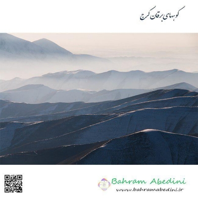
قله چشمه شاهی به ارتفاع سه هزارو دویست و هشتاد متر این کوه در شمال غرب تهران واقع شده است. در شرق این قله روستای سنگان، در جنوب شرقی آن روستای کشار علیا، در غرب روستای چاران و آبشار زیبای چاران و در شمال غربی آن روستای خور و در شمال قله پهنه حصار واقع شده است که در حقیقت با قله پهنه حصار و قله بارو یال مشترک دارد قله چشمه شاهی در نقشه ها جزو استان تهران میباشد ولی جزو حوزه آبریز رودخانه کرج هست آبشارهای که از این کوه به پائین می ریزد عبارت از آبشار خور -_ چاران _ کندور _ ده سر _ سکوت یزدان _ سر تنگه _ آرزوها _
به این عکس امتیاز دهید.
این عکس توسط بهرام عابدینی از تپه ها و طبیعت اطراف این منطقه گرفته شده است. برای خرید این عکس یا عکس های دیگر از طریق وبسایت یا تلفن با ما تماس بگیرید.
توضیحات انگلیسی:
Cheshmeh Shahi Peak, with an elevation of 3,280 meters, is located in the northwest of Tehran. To the east of this peak is the village of Sangan, to the southeast is the village of Keshar Aliya, to the west is the village of Charan and the beautiful Charan Waterfall, and to the northwest is the village of Khor. To the north of the peak is Pahneh Hesar, which shares a ridge with Baro Peak. Although Cheshmeh Shahi Peak is marked as part of Tehran province on maps, it belongs to the Karaj River watershed. The waterfalls descending from this mountain include Khor Waterfall, Charan Waterfall, Kondor Waterfall, Deh Sar Waterfall, Sokut Yazdan Waterfall, Sar Tange Waterfall, and Arezuha Waterfall.
Please rate this picture.
This picture is taken by Bahram Abedini. If you want to purchase this picture or any other around this area please contact us through website, email or phone.
We sell pictures digitally in Large format and internationally through secure paypal payment in the US.
Farsi Description:
قله لیچه به ارتفاع 2900 در استان البرز در شرق روستای کندور و در غرب روستای واریش تهران قرار دارد مسیرهای صعود روستای کندور و روستای واریش میباشد لیچه همجوار با کوه چشمه شاهی ودر ادامه یال به قله لیز و لیزان متصل می شود ارتفاع قله 2900 متر واین عکس از جاده قدیم کندور زیر قله پورا گرفته شده
به این عکس امتیاز دهید.
این عکس توسط بهرام عابدینی از تپه ها و طبیعت اطراف این منطقه گرفته شده است. برای خرید این عکس یا عکس های دیگر از طریق وبسایت یا تلفن با ما تماس بگیرید.
توضیحات انگلیسی:
"Liche Peak, with an elevation of 2900 meters, is located in Alborz Province, east of Kondor village and west of Varish village in Tehran. The ascent routes are from Kondor village and Varish village. Liche is adjacent to Cheshmeh Shahi mountain and continues along the ridge to connect to Liz and Lizan peaks. The elevation of the peak is 2900 meters, and this photo was taken from the old Kondor road below Pura Peak."
Please rate this picture.
This picture is taken by Bahram Abedini. If you want to purchase this picture or any other around this area please contact us through website, email or phone.
We sell pictures digitally in Large format and internationally through secure paypal payment in the US.
Farsi Description:
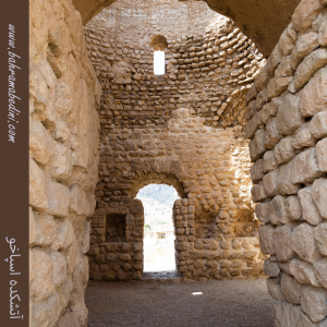
مسجد استاد و شاگرد یکی از مساجد تاریخی و معروف شهر اصفهان است. این مسجد در دوره صفویه ساخته شده و به دلیل معماری زیبا و کاشیکاریهای منحصر به فردش شهرت دارد. مسجد استاد و شاگرد به دو بخش اصلی تقسیم میشود: بخش استاد که بزرگتر و مجللتر است و بخش شاگرد که کوچکتر و سادهتر است. این تقسیمبندی نمادی از رابطه استاد و شاگرد در فرهنگ ایرانی است.
به این عکس امتیاز دهید.
این عکس توسط بهرام عابدینی از تپه ها و طبیعت اطراف این منطقه گرفته شده است. برای خرید این عکس یا عکس های دیگر از طریق وبسایت یا تلفن با ما تماس بگیرید.
توضیحات انگلیسی:
The Masjid-e Ustad va Shagird (Mosque of Master and Disciple) is one of the historic and renowned mosques in the city of Isfahan. Built during the Safavid era, this mosque is famous for its beautiful architecture and unique tile work. The mosque is divided into two main sections: the master's section, which is larger and more ornate, and the disciple's section, which is smaller and simpler. This division symbolizes the relationship between master and disciple in Iranian culture.
Please rate this picture.
This picture is taken by Bahram Abedini. If you want to purchase this picture or any other around this area please contact us through website, email or phone.
We sell pictures digitally in Large format and internationally through secure paypal payment in the US.

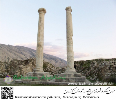
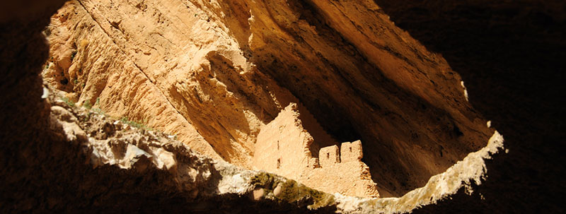
مسجد جامع ریجاب یکی از آثار باستانی و ارزشمند در استان کرمانشاه، ایران، است. این مسجد در نزدیکی روستای ریجاب و در شهرستان دالاهو قرار دارد و یکی از بناهای تاریخی مربوط به دوران صدر اسلام به شمار میآید. معماری این مسجد ترکیبی از سادگی و زیبایی خاص معماری اسلامی اولیه است.
این مسجد به خاطر ویژگیهای معماری و قدمتش، جزو میراث فرهنگی ایران محسوب میشود. از جمله ویژگیهای جالب آن میتوان به مصالح استفادهشده مانند سنگ و گل، و همچنین ایوانها و قوسهای ساده اما تأثیرگذار اشاره کرد. محوطه اطراف این مسجد نیز فضای زیبا و آرامبخشی دارد که بازدید از آن را لذتبخشتر میکند.
Farsi Description:
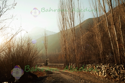
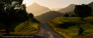
سپید دشت یکی از مناطق زیبا و دیدنی استان لرستان در ایران است. این منطقه به خاطر طبیعت بکر و مناظر طبیعی خیرهکنندهاش شناخته میشود. سپید دشت دارای کوهها، جنگلها و رودخانههای فراوانی است که آن را به مقصدی محبوب برای طبیعتگردان و علاقهمندان به ماجراجویی تبدیل کرده است. همچنین، این منطقه دارای آب و هوای معتدل و دلپذیری است که در فصول مختلف سال جذابیت خاصی به آن میبخشد.
به این عکس امتیاز دهید.
این عکس توسط بهرام عابدینی از تپه ها و طبیعت اطراف این منطقه گرفته شده است. برای خرید این عکس یا عکس های دیگر از طریق وبسایت یا تلفن با ما تماس بگیرید.
توضیحات انگلیسی:
Sepid Dasht is one of the beautiful and scenic areas in Lorestan province, Iran. This region is known for its pristine nature and stunning landscapes. Sepid Dasht features mountains, forests, and numerous rivers, making it a popular destination for nature enthusiasts and adventure seekers. Additionally, the area enjoys a mild and pleasant climate, adding to its charm throughout the year.
Please rate this picture.
This picture is taken by Bahram Abedini. If you want to purchase this picture or any other around this area please contact us through website, email or phone.