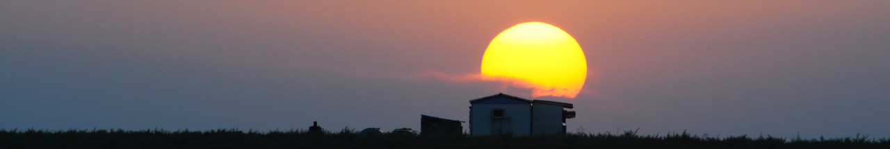
آخرین عکس های طبیعت و مناظر ایران
بهرام عابدینی
آخرین عکس های طبیعت و مناظر ایران
آخرین عکس های طبیعت و مناظر ایران
بهرام عابدینی
بهرام عابدینی
Website Language

")
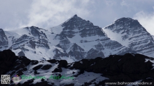
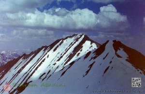
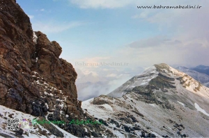
قله های شاه البرز که در شمال ایران قرار دارد شامل 5 قله میباشد که از فصل زمستان تا بعد از بهار همچنان پوشیده از برف است. رگه های صخره ای به این کوه در زمستان همراه با برف ابهت بسیاری میبخشد که در عکس فوق قابل مشاهده است.
The 5 peaks of Shah-Alborz or (King of Alborz) are situated in the northern part of Iran where the Alborz mountain series are. The boulder stony mountain and the snow make these peaks a very spectacular place to take pictures.
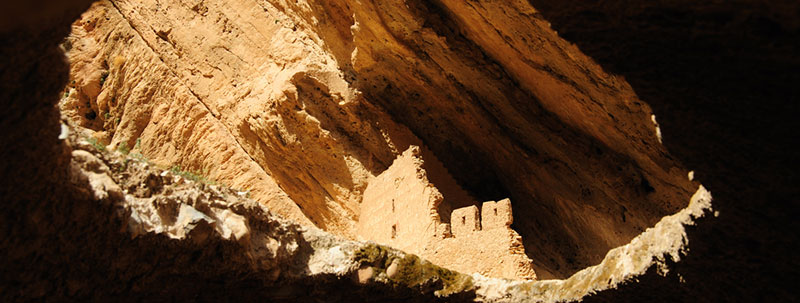
قلعه بهستان یا کهن دژ در شهرستان ماهنشان در استان زنجان و در نزدیکی روستای بهستان و در کنار رود قزل اوزن جای گرفتهاست.بنای نخستین این دژ منسوب به دوره ساسانی است اما در دوره اسلامی و سدههای ۵ تا ۷ هجری مورد استفاده بودهاست.برخی از مردم محلی این آثار را به دلیل شکل عجیبشان «دودکش جن» یا «تخت دیو» مینامند.سازندگان قلعه با در نظر داشتن طرح اولیه، اقدام به کندن کوه و تخلیه خاکها و سنگها کردهاند و اتاقها را به وجود آوردند و به هر تعدادی که به اتاقهای آن اضافه شده راههای ارتباطی آنها به مجموعه نیز به صورت دالانهایی افزوده شدهاست.[۲] فضای کلی قلعه به سه دسته شامل اتاقها، دالانها و راهپلهها تقسیم میگردیدهاست که گاه دارای سقفی تیزهدار و دارای محلهایی به شکل مثلث یا مدور روی دیوارها برای قرار گرفتن پیهسوز بودهاست.اهپلههای ضلع شمال غربی قلعه به عنوان یکی از مناطق دست نخورده و سالم دژ بهستان است که بالای این پلهها، اتاقی به شکل طاق محرابهای مسجد دوران اسلامی تزئین شده متعلق به دوره اسلامی وجود دارد و راهپلههای زیاد با عرض یک متر نیز اقتباس از این سبک معماری است. هم اکنون به دلیل تخریب زیاد تنها با عملیات کوهنوردی میتوان بر بالای قلعه با تخته سنگهای عظیم مسطح آن رسید. قسمت بالای قلعه با گچ اندوده شده و داخل آن حوضی با ابعاد ۷ در ۳ متر و از جنس سنگ و ساروج قرار دارد که با استفاده از لولههای آب گلی نیممتری به اسم «گنگ» آب آن تأمین میشدهاست..
Behestan Castle is located next to Qizil Üzan River and the village of Behestan, ten kilometers southeast of the city Mahneshan and one hundred kilometers west of Zanjan.Behestan Castle is located next to Qizil Üzan River and the village of Behestan, ten kilometers southeast of the city Mahneshan and one hundred kilometers west of Zanjan.On the southern sides of the Qizil Üzan River that sources from heights of Chehel Cheshmeh in Kordestan and end up entering the Caspian Sea, in the land called Mahneshan where once the Medes lived, there are two megaliths made of sandstone. They are about one hundred meters distant from each other and are located two thousand and five hundred meters higher than sea level.Thousands of years of rain, lashes of the wind, and cycles of warmth and cold have eroded these Iranian man-made structures. After so many years of erosion, what remains of them is called Dudkesh-e Jen and Takht-e Div by local people. The Specialists speculate that the name Mahneshan is on one hand related to the Medes people. The Madabad Village close to this area is a proof of this. On the other hand, they believe that it can be the changed form of the word Meynushan (drinkers of the wine).Behestan Castle of Mahneshan traces back to ancient Iran. It was the habitat of humans in the middle centuries, from one thousand and three hundred B.C. to five hundred years ago. The structures dug into the mountain include corridors and staircases that have been combined with vaults and shelves on different parts of the megalith. The remaining part of this historical structure shows that it had more than one story. The staircase is built in the form of zigzag and the rooms have gradually been added to the castle. In the upper section of the castle there is a part that has a coat of plaster. It has a pool made from stone and Sarooj that is a certain kind of water-resistant mortar. The pool is seven meters tall and three meters wide. It is fed by a kind of Tanbusheh clay pipes called Gang.
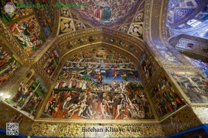
وانک نام کلیسایی در محله جلفای اصفهان می باشد. ارامنه بعد از کوچ بزرگ 1605 در زمان شاه عباس دوم شروع به ساخت این کلیسا کردند و نهایتا در سال 1664 ساخت این بنا به اتمام رسید. کلیسای وانک دارای نقاشی های بسیار زیبای دیواری، تابلوهای رنگ روغن،کتاب های قدیمی و بسیاری اشیا با ارزش دیگر میباشد.
این کلیسا در کل به چهاربخش اصلی تقسیم می شود: چاپخانه ، کتابخانه، موزه و اماکن اداری. مساحت این کلیسا 8731 متر مربع است. نام دیگر این کلیسا آمنا پرکیج می باشد. کلیسای آمنا پرکیج بر خلاف کلیساهای کهن ارمنی که بیشتر با سنگ ساخته شدهاند، با خشت خام بنا گردیدهاست. دیوار بیرونی کلیسا با آجر و دیوار درونی آن را با اندود گچ که بر روی آن نقاشی و تزیین شده پوشاندهاند. کلیسا دارای دو گنبد است؛ گنبد کوچک بر روی محل استقرار عامه مردم قرار دارد، و گنبد بزرگ بر روی قسمت مقدم محراب کلیسا ساخته شدهاست. ارتفاع دیوارهای کلیسا از سطح حیاط تا بام طبقه دوم ۱۱/۷۵ متر است. در داخل کلیسا، در فاصله ۶/۲۵ متری دیوار غربی آن، دو ستون مربع که هر یک از اضلاع آن دو متر است احداث شدهاست. در بخش غربی کلیسا با استفاده از بخشی از این ستونها و پایههای دیوارهای جانبی چهار طاق نمای بلند ساختهاند؛ ارتفاع این طاق نماها ۱۰/۲۵ متر است. گنبد کوچک کلیسا که ارتفاع چندانی ندارد، بر روی این طاق نماها قرار دارد کلیساهای کهن ارمنی مخروطی شکل است، ولی گنبد کلیسای وانک شبیه گنبد مساجد ایرانی عصر صفوی ساخته شدهاست. در بام کلیسا، در قسمت فوقانی درِ ورودی حد فاصل دیوار غربی و حاشیه گنبد کوچک کلیسا، در محوطهای مربع مانند، برج ناقوس کوچکی که دومین برج ناقوس کلیسا است ساخته شدهاست. هر ضلع این مربع ۲/۷۵ متر است. در نقطه تلاقی هر دو ضلع مربع مزبور یک ستون آجری بنا کردهاند؛ ارتفاع این ستونها سه متر است و در ارتفاع ۲/۵ متری آنها، هر دو ستون به وسیله یک تیر چوبی به یکدیگر متصل شدهاند. از قسمت فوقانی تیرهای مزبور هر دو ستون با یک قوس جناغی به یکدیگر اتصال یافتهاند. حد فاصل قوسهای جناغی و ستونها را با آجر پوشاندهاند.
Vank cathedral or Amena Pergic, the largest and most beautiful cathedral in Isfahan’s Julfa, one of the historical Armenian cathedrals, was established in the Shah Abbas II era in the lands of Zereshk garden in 1605; it was extended continuously during 50 years and finally reached to the current form.Vank cathedral or Amena Pergic, the largest and most beautiful cathedral in Isfahan’s Julfa, one of the historical Armenian cathedrals, was established in the Shah Abbas II era in the lands of Zereshk garden in 1605; it was extended continuously during 50 years and finally reached to the current form.The plan of the cathedral is rectangular and its direction is eastern-western. The interior of cathedral presents a sample of Armenian architecture and its exterior facade has been designed by use of Iranian architecture and it is a professional combination of two architectural styles.The materials used in the building of Vank cathedral were brick and adobe and all the interior angles of cathedral covered by plaster and decorated by oil paint and gold in Iranian style and some images from Jesus (peace be upon him) life affected by Italian painting.Belfry, in front of the main entrance of the cathedral has been constructed in Iranian style in the Shah Soltan Hossein era. This cathedral includes a dome, tall walls and high and beautiful roofs that is the Armenian vicarage of Iran and India.There are the graves of Khachatur Kesaratsi (the father of publishing industry) and David (archbishop) in the yard of the cathedral. Museum, library and offices are the surrounding buildings of Vank cathedral.
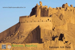
ارگ بم بزرگترین سازهٔ خشتی در جهان بود که محل آن در شهر بم در استان کرمان در جنوب شرقی ایران قرار دارد.زلزله سال ۲۰۰۳ در بم بیشتر از ۸۰ درصد ارگ را ویران کرد.ارگ بم بزرگترین سازهٔ خشتی در جهان بود که محل آن در شهر بم در استان کرمان در جنوب شرقی ایران قرار دارد.زلزله سال ۲۰۰۳ در بم بیشتر از ۸۰ درصد ارگ را ویران کرد این ارگ عظیم که در مسیر جادهٔ ابریشم قرار دارد سده 5 پیش از میلاد ساخته شده است و تا سال 1850 پس از میلاد نیز همچنان مورد استفاده بودوسعت مجموعه ارگ بم که شهر قدیمی و ارگ را در دل خود جای داده، 20 هکتار تخمین زده شده و مساحت خود قلعه که در گذشته مرکز سیاسی شهر به شمار می رفته تقریبا 6 هکتار است. امروزه تنها از دروازه جنوبی ارگ استفاده می شودبه طور کلی مجموعه ارگ بم از دروازه اصلی، بازار، میدان اصلی، مسجد بزرگ ارگ، مجموعه میرزا نعیم، مسجد کوچک، کاروانسرا، زورخانه، حمام ارگ، دروازه حصار دوم، مسجد ارگ، اصطبل، اسلحه خانه، آسیاب بادی، خانه حاکم، چهار فصل، چاه اصلی ارگ، باقیمانده های حصار قدیم، محله قلام یا کناری، زندان و دروازه کت کرم می باشد
The Arg-e Bam is the largest adobe building in the world, located in Bam, a city in Kerman Province of southeastern Iran. It is listed by UNESCO as part of the World Heritage Site "Bam and its Cultural Landscape". The origin of this enormous citadel on the Silk Road can be traced back to the Achaemenid Empire (sixth to fourth centuries BC) and even beyond. The heyday of the citadel was from the seventh to eleventh centuries, being at the crossroads of important trade routes and known for the production of silk and cotton garments.
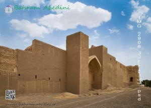
خوسف از شهرهای استان خراسان جنوبی می باشد که دارای یک تالاب،خانه های قدیمی، مسجد جامع، چندین آب انبار و هم چنین ساباط های زیبا می باشد. هم چنین خوسف محل تولد بانو سیما بینا نیز می باشد. این عکس قلعه قدیمی خوسف می باشد که مربوط به دوره افشاریه می باشد. قسمت هایی از این قلعه در سال 93 مورد مرمت قرار گرفت؛ از جمله پایه های اطراف سردر ورودی و طاق سردر. هم چنین این قعله دارای برج های استوانه ای شکل در اطراف می باشد. اما در حال حاضر کاربری این بنا به صورت انبار کالا درآمده است.
Josef is one of the cities in South Khorasan province with a lagoon, old houses, a mosque, several storage rooms and also beautiful interiors. Khossef is also the birthplace of Lady Sima Bina. This is a photo of the old fortress of Khusuf, which belongs to the Afshariyyah period. Parts of the castle were renovated in 2014, including basements around the entrance porch and the arch. It also has cylindrical towers around it. But now the building has become a warehouse.
قله خرس چال (ارتفاع 4100متر ) و بزچال (ارتفاع 4050) از جمله قله های البرز مرکزی می باشند. نام دیگر این دو قله سرک چالِ 2 و 3 نیز می باشد. خط الراس آن به ترتیب بدین صورت می باشد: سرک چال، خرس چال و بزچال، گلون بستک و سه چال. براس صعود می توان از دو مسیر استفاده کرد. نخست از سمت شمشک؛ زمان حدودی تا قله 6 ساعت می باشد. و مسیر دوم ، مسیر شمالی می باشد که از دره دریوک عبور می کند.
The peaks of Khers-chal (4100 H) and Bezchal (4050 H) are central Alborz peaks. Another name for these two peaks is Sarak-chal 2 and 3. The ridge is as follows:Sarak-chal, Kolun-bastak,Seh-chal and sekke-nou. Climbing can be available in two ways: First from Shemshak; time is approximately 6 hours. And the second route is the northern route that crosses the Druuk Valley.
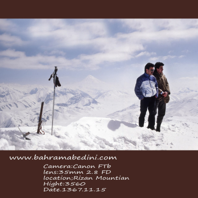
قله ریزان در البرز مرکزی بخش لواسانات، نزدیکی روستای افجه قرار دارد. ارتفاع این قله 3700 متر از سطح دریا می باشد.این عکس از روی خط الراس آتشکوه گرفته شده است. برای رسیدن به این قله می توانید از دو مسیرِ دشت هویج و دشت گردو استفاده کنید. از روی قله ریزان می توان دشت لار و هم چنین قله دماوند را مشاهده کرد. از کوه های اطراف این قله می توان به سیاه چالِ یک و دو وسه،اَندَر، پُرسون، آتشکوه، مهرچال، و پیرزن گلون اشاره کرد. هم چنین آبشار سوستون نیز در این منطقه قرار دارد.
Rizan Peak is located in the central Alborz section of Lavasanat, near the village of Afjeh. The summit is 3700 meters above sea level. This photo was taken on a ridge of fire. To reach this peak you can use the two paths of carrot and walnut. From the summit of Lizan plain can be seen as well as Damavand peak. Mountains around the summit can be found in the dungeons of One and Two Vose, Ender, Persson, Atashkouh, Mehrchal, and Old Glen. There is also the Suston Falls in the area.
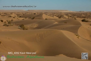
مصر نام روستای کوچکی است که در 55 کیلومتری شهرستان خور از توابع استان اصفهان واقع شده و ۱۸۰ نفر(41 خانوار) جمعیت دارد .مصر در میانه راه دامغان به نائین و اصفهان قرار دارد. این کویر توسط رشته کوههایی از جانب غرب، جنوب غرب و جنوب شرق محاصره میشود که بخشی از سلسله جبال کوههای فلات مرکزی ایران به حساب میآیند. این کویر در گودالهایی طبیعی در کوهپایههای این کوهها، تپههای ماسهای زیبایی را تشکیل داده است.
Messr is the name of a small village in a beautiful desert located 55 kilometers from the city of Khor of Isfahan province and has a population of 180 people (41 households). The desert is surrounded by mountain ranges from the west, southwest and southeast that form part of the mountains of the Central Plateau of Iran. The desert forms beautiful sand dunes in natural pits in the foothills of these mountains.
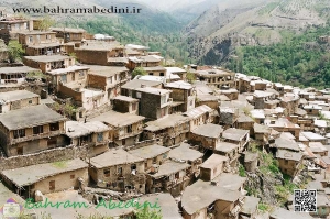
این روستا در دامنه کوه های بینالود و در ۱۹ کیلومتری غرب طرقبه و ۲۹ کیلومتری مشهد واقع شده است. ادارای قدمتی طولانی می باشد و به دلیل استقرار سکونت گاه های آن بر روی کوهپایه شکلی پلکانی پیدا کرده است.همچنین این روستا دارای آب و هوای معتدل و چشم اندازهای زیبای کوهستانی ، رودخانه و چشمه می باشد. ارتفاع آن از سطح دریا 1800 متر می باشد. براساس سرشماری مرکز آمار ایران در سال ۱۳۸۵، جمعیت آن ۱٬۴۷۲ نفر (۳۵۴ خانوار) بودهاست. ولی در سال ۱۳۹۰ جمعیت این روستا به ۷۹۹ نفر (۲۷۱ خانوار) کاهش یافتهاست..
The Kang village is located on the slopes of the Binalood Mountains,. The village has a long history and is a stepped slope due to its settlements.The Kang village is located on the slopes of the Binalood Mountains, 2 km west of Tarkheba and 2 km from Mashhad. The village has a long history and is a stepped slope due to its settlements.The village also has temperate climate and beautiful mountain, river and fountain views. Its altitude is 1800 meters. According to the Census Bureau of Iran in year 2, its population was 2.7 (2 households). But in year 2 the population of this village has been reduced to 4 persons (2 households).
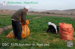
عیش آباد روستایی در نیشابور و در استان خراسان رضوی می باشد.این روستا دارای مسیری برای صعود به قله بینالود می باشد. عیش آباد روستایی در نیشابور و در استان خراسان رضوی می باشد.این روستا دارای مسیری برای صعود به قله بینالود می باشد. براساس سرشماری مرکز آمار ایران در سال ۱۳۸۵، جمعیت آن ۱۵۸ نفر (۳۷خانوار) بوده است.
Eyshabad is a village in Mazul Rural District, in the Central District of Nishapur County, Razavi Khorasan Province, Iran. At the 2006 census, its population was 158, in 37 families.