آخرین عکس های طبیعت و مناظر ایران
بهرام عابدینی
آخرین عکس های طبیعت و مناظر ایران
آخرین عکس های طبیعت و مناظر ایران
بهرام عابدینی
بهرام عابدینی
Website Language

")
Farsi Description:
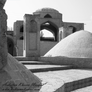
مسجد خسرو یکی از بناهای تاریخی شهر اردستان در استان اصفهان است که در دوره صفوی ساخته شده. این مسجد که به «مسجد آخوند» نیز معروف است، در محله راهمیان و خیابان دوازدهم بهمن قرار دارد و بهعنوان یکی از آثار ملی ایران به ثبت رسیده است.
به این عکس امتیاز دهید.
این عکس توسط بهرام عابدینی از تپه ها و طبیعت اطراف این منطقه گرفته شده است. برای خرید این عکس یا عکس های دیگر از طریق وبسایت یا تلفن با ما تماس بگیرید.
توضیحات انگلیسی:
Khosrow Mosque is a historical building located in the city of Ardestan, in Isfahan Province, Iran. It was built during the Safavid era and is also known as “Akhund Mosque.” Situated in the Rahmiyan neighborhood on 12th Bahman Street, it has been registered as a national heritage site of Iran.
Please rate this picture.
This picture is taken by Bahram Abedini. If you want to purchase this picture or any other around this area please contact us through website, email or phone.
We sell pictures digitally in Large format and internationally through secure paypal payment in the US.
Farsi Description:
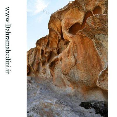
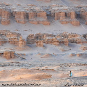
کویر لوت، که به عنوان دشت لوت نیز شناخته میشود، یک بیابان نمکی وسیع در جنوب شرقی ایران است. این یکی از گرمترین و خشکترین مکانهای زمین است که دمای سطح آن به شدت بالا میرسد. این بیابان حدود ۵۱٬۸۰۰ کیلومتر مربع را پوشش میدهد و دارای ویژگیهای زمینشناسی منحصر به فردی مانند یاردانگهای عظیم، بیابانهای سنگی گسترده و برخی از بلندترین تپههای شنی جهان است. این منطقه بادهای قوی را تجربه میکند که چشمانداز دراماتیک آن را شکل میدهند. در سال ۲۰۱۶، بیابان لوت به عنوان یک سایت میراث جهانی یونسکو به دلیل زیبایی طبیعی و اهمیت زمینشناسی آن شناخته شد.
به این عکس امتیاز دهید.
این عکس توسط بهرام عابدینی از تپه ها و طبیعت اطراف این منطقه گرفته شده است. برای خرید این عکس یا عکس های دیگر از طریق وبسایت یا تلفن با ما تماس بگیرید.
توضیحات انگلیسی:
The Lut Desert, also known as Dasht-e Lut, or Kavir_e Lut is a vast salt desert in southeastern Iran. It is one of the hottest and driest places on Earth, with surface temperatures reaching extreme highs. Covering about 51,800 square kilometers, it features unique geological formations like massive yardangs, extensive stony deserts, and some of the world's tallest sand dunes. The region experiences strong winds that shape its dramatic landscape. In 2016, the Lut Desert was recognized as a UNESCO World Heritage Site for its natural beauty and geological significance.
Please rate this picture.
This picture is taken by Bahram Abedini. If you want to purchase this picture or any other around this area please contact us through website, email or phone.
We sell pictures digitally in Large format and internationally through secure paypal payment in the US.
Farsi Description:
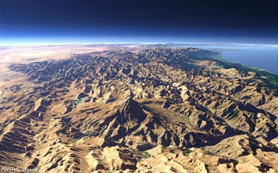
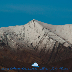
قله منا ر و گلوی به ارتفاع تقریبی سه وهزارو پانصد متر در شمال روستای واریان وجنوب شرقی روستای مورودقرار دارد این دوقله در خطالراس سیاه سنگ منار و گلوی و گلو سربند واقع است راه صعود به قله بیشتر از روستای مورود است آبشار های که از قله ها سرازیر می شود یکی آبشا ر چهار صد تنور در جنوب و آبشار رفک در شمال این کوه قرار دارد.
به این عکس امتیاز دهید.
این عکس توسط بهرام عابدینی از تپه ها و طبیعت اطراف این منطقه گرفته شده است. برای خرید این عکس یا عکس های دیگر از طریق وبسایت یا تلفن با ما تماس بگیرید.
توضیحات انگلیسی:
Please rate this picture.
The peaks of Manar and Golou, with an approximate height of 3,500 meters, are located north of the village of Varyan and southeast of the village of Moroud. These two peaks are situated on the ridge of Siah Sang Manar and Golou and Golou Sarband. The main route to ascend the peaks is from the village of Moroud. The waterfalls that flow from the peaks include the Four Hundred Tanur waterfall in the south and the Rafak waterfall in the north of this mountain."
This picture is taken by Bahram Abedini. If you want to purchase this picture or any other around this area please contact us through website, email or phone.
We sell pictures digitally in Large format and internationally through secure paypal payment in the US.
Farsi Description:
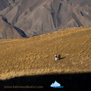
قله پورا از جنوب به روستای کندر ، از شمال به روستای ابهرک و ارنگه ، از غرب به روستای آدران و از شرق بر روی خط الراس قلل چال ، سیوچال ، درزو و پشته بند محراب چشمه شاهی قله پهنه سار امتداد دارد مسیرهای صعود جاده قدیم کندور دره گلنا و آبشار نمرک و روستای ابهرک ارتغاع قله دوهزارو نصد متر است
به این عکس امتیاز دهید.
این عکس توسط بهرام عابدینی از تپه ها و طبیعت اطراف این منطقه گرفته شده است. برای خرید این عکس یا عکس های دیگر از طریق وبسایت یا تلفن با ما تماس بگیرید.
توضیحات انگلیسی:
Pura Peak is bordered to the south by the village of Kondor, to the north by the villages of Abharak and Arangeh, to the west by the village of Adran, and to the east along the ridge line of Chal, Sivchal, Darzu, and Pusht-e Band Mehrab Cheshmeh Shahi peaks, extending to Pahne Sar Peak. The ascent routes include the old Kondor Road, Golna Valley, Namrak Waterfall, and the village of Abharak. The peak's elevation is 2,900 meters.
Please rate this picture.
This picture is taken by Bahram Abedini. If you want to purchase this picture or any other around this area please contact us through website, email or phone.
We sell pictures digitally in Large format and internationally through secure paypal payment in the US.
Farsi Description:
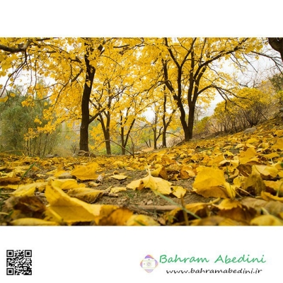
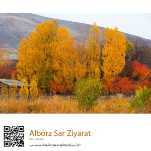
سر زیارت روستایی زیبا در جاده چالوس و نزدیک کرج است. این روستا به دلیل طبیعت سرسبز و چشمه قلقلک معروف است و حدود ۲۵۰ نفر جمعیت دارد.
در پاییز، سر زیارت به منظرهای خیرهکننده از رنگهای زنده تبدیل میشود. درختان با نمایش طیفی از قرمز، نارنجی و زرد، صحنهای زیبا و شبیه به نقاشی ایجاد میکنند. هوای خنک و خشخش برگها زیر پا، به جذابیت این منطقه میافزاید و آن را به مقصدی ایدهآل برای عاشقان طبیعت تبدیل میکند که به دنبال آرامش و زیبایی هستند.
به این عکس امتیاز دهید.
این عکس توسط بهرام عابدینی از تپه ها و طبیعت اطراف این منطقه گرفته شده است. برای خرید این عکس یا عکس های دیگر از طریق وبسایت یا تلفن با ما تماس بگیرید.
توضیحات انگلیسی:
Sar Ziarat is a beautiful village located along the Chalus Road near Karaj. Known for its lush greenery and the famous Qolqolak Spring, this village offers a peaceful retreat with a small population of around 250 people.
In autumn, Sar Ziarat transforms into a breathtaking landscape of vibrant colors. The trees display a stunning array of reds, oranges, and yellows, creating a picturesque scene that feels like a painting. The crisp air and the rustling of leaves underfoot add to the charm, making it an ideal destination for nature lovers seeking tranquility and beauty.
Please rate this picture.
This picture is taken by Bahram Abedini. If you want to purchase this picture or any other around this area please contact us through website, email or phone.
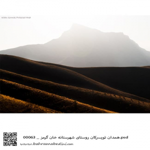
قله خان گرمز در شهر تویسرکان در نزدیکی همدان
The Mountain of Khan-garmaz
In the Vicinity of Hamedan (modern Hegmatane) the capital of the Medes.
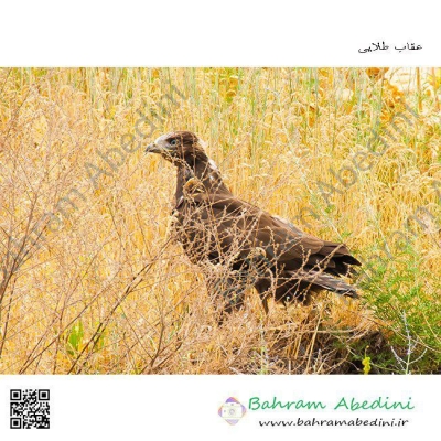
A beautiful pristine nature with a good wildlife.
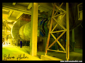
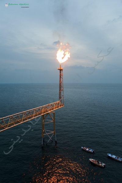
عکاسی از خط تولید شرکت سامان کاشی. در این عکس شما شاهد سازه ی بال میل که برای ساییدن مواد اولیه به مواد نرم تر استفاده میشود
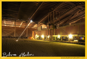
در پروژه تولید سیمان در یکی از بخش ها عملیات خشک سازی مواد اولیه صورت میگیرد که در سوله ای با استفاده از خشک کن های صنعتی این کار انجام میشود. در پروژه فوق از مراحل تولید عکس صنعتی گرفته شده است که نمونه ای از آن را در اینجا میتوانید مشاهده کنید. اگر پروژه ای مشابه دارید که برای کارخانه خود در صدد تهیه عکس و فیلم هستید با ما تماس بگیرید.
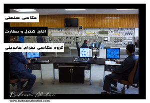
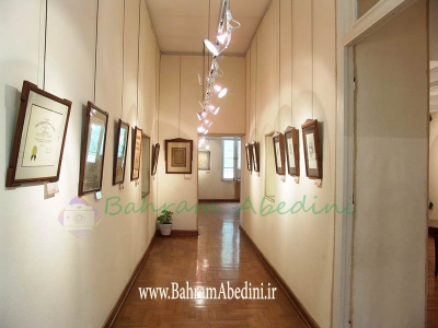
در این پروژه از دفاتر و پرسنل شرکت سیمان عکاسی شد . پس از آماده سازی محل عکاسی و هماهنگی با پرسنل این عکس از اتاق کنترل و نظارت کارخانه گرفته شد. برای سفارش پروژه عکاسی از کارخانه خود با ما تماس بگیرید.
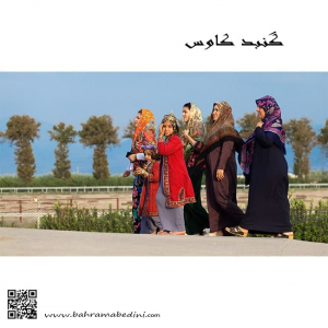
Group of women In local costumes
North Iran , Gonbad Kavoos
گروهی از زنان گنبد کاووس در راه مراسم عروسی