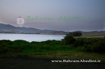
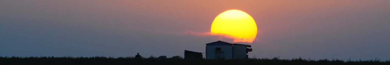
آخرین عکس های طبیعت و مناظر ایران
بهرام عابدینی
آخرین عکس های طبیعت و مناظر ایران
آخرین عکس های طبیعت و مناظر ایران
بهرام عابدینی
بهرام عابدینی
Website Language

")
Farsi Description:
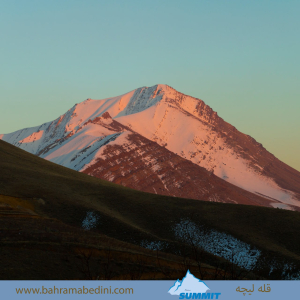
قله لیچه به ارتفاع 2900 در استان البرز در شرق روستای کندور و در غرب روستای واریش تهران قرار دارد مسیرهای صعود روستای کندور و روستای واریش میباشد لیچه همجوار با کوه چشمه شاهی ودر ادامه یال به قله لیز و لیزان متصل می شود ارتفاع قله 2900 متر واین عکس از جاده قدیم کندور زیر قله پورا گرفته شده
به این عکس امتیاز دهید.
این عکس توسط بهرام عابدینی از تپه ها و طبیعت اطراف این منطقه گرفته شده است. برای خرید این عکس یا عکس های دیگر از طریق وبسایت یا تلفن با ما تماس بگیرید.
توضیحات انگلیسی:
"Liche Peak, with an elevation of 2900 meters, is located in Alborz Province, east of Kondor village and west of Varish village in Tehran. The ascent routes are from Kondor village and Varish village. Liche is adjacent to Cheshmeh Shahi mountain and continues along the ridge to connect to Liz and Lizan peaks. The elevation of the peak is 2900 meters, and this photo was taken from the old Kondor road below Pura Peak."
Please rate this picture.
This picture is taken by Bahram Abedini. If you want to purchase this picture or any other around this area please contact us through website, email or phone.
We sell pictures digitally in Large format and internationally through secure paypal payment in the US.
Farsi Description:
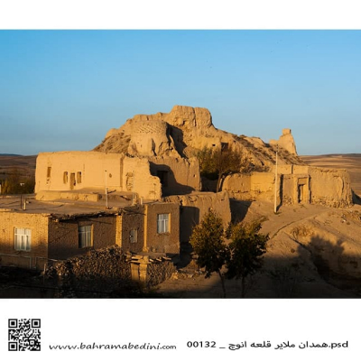
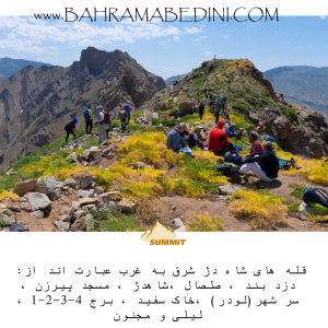
شاه دژ، دزدبند، صلصال، مسجد پیرزن، سر شهر (لودر)، خاک سفید، قلههای برج، و کوه لیلی و مجنون هر کدام دارای ویژگیهای خاص و تاریخی هستند. شاه دژ و قلههای برج در رشتهکوه البرز قرار دارند و به دلیل دیوارههای سنگی و چشماندازهای زیبا، مقصدی محبوب برای کوهنوردان هستند. دزدبند و صلصال قلعههای تاریخی با معماری خاص و موقعیت استراتژیک هستند. مسجد پیرزن در بوشهر توسط پیرزنی ساخته شده و برهسر در گیلان به دلیل طبیعت بکر و پوشش گیاهی انبوه، مقصدی محبوب برای گردشگران است. کوه سفید به دلیل معادن گچ خود معروف است و داستان عاشقانه لیلی و مجنون به کوه لیلی و مجنون اشاره دارد.
به این عکس امتیاز دهید.
این عکس توسط بهرام عابدینی از تپه ها و طبیعت اطراف این منطقه گرفته شده است. برای خرید این عکس یا عکس های دیگر از طریق وبسایت یا تلفن با ما تماس بگیرید.
توضیحات انگلیسی:
Shah Dej, Dozdband, Salsal, Masjed Pirzan, Sar Shahr (Loader), Khak Sefid, Borj Peaks, and Lili and Majnun Mountain each have unique historical and natural features. Shah Dej and Borj Peaks are located in the Alborz mountain range and are popular destinations for mountaineers due to their rocky walls and beautiful landscapes. Dozdband and Salsal are historical castles with distinctive architecture and strategic locations. Masjed Pirzan in Bushehr was built by an elderly woman, and Bareh Sar in Gilan is a popular tourist destination due to its pristine nature and dense vegetation. Khak Sefid is known for its gypsum mines, and the romantic story of Lili and Majnun is associated with Lili and Majnun Mountain.
Please rate this picture.
This picture is taken by Bahram Abedini. If you want to purchase this picture or any other around this area please contact us through website, email or phone.
We sell pictures digitally in Large format and internationally through secure paypal payment in the US.
Farsi Description:
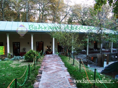
مسجد استاد و شاگرد یکی از مساجد تاریخی و معروف شهر اصفهان است. این مسجد در دوره صفویه ساخته شده و به دلیل معماری زیبا و کاشیکاریهای منحصر به فردش شهرت دارد. مسجد استاد و شاگرد به دو بخش اصلی تقسیم میشود: بخش استاد که بزرگتر و مجللتر است و بخش شاگرد که کوچکتر و سادهتر است. این تقسیمبندی نمادی از رابطه استاد و شاگرد در فرهنگ ایرانی است.
به این عکس امتیاز دهید.
این عکس توسط بهرام عابدینی از تپه ها و طبیعت اطراف این منطقه گرفته شده است. برای خرید این عکس یا عکس های دیگر از طریق وبسایت یا تلفن با ما تماس بگیرید.
توضیحات انگلیسی:
The Masjid-e Ustad va Shagird (Mosque of Master and Disciple) is one of the historic and renowned mosques in the city of Isfahan. Built during the Safavid era, this mosque is famous for its beautiful architecture and unique tile work. The mosque is divided into two main sections: the master's section, which is larger and more ornate, and the disciple's section, which is smaller and simpler. This division symbolizes the relationship between master and disciple in Iranian culture.
Please rate this picture.
This picture is taken by Bahram Abedini. If you want to purchase this picture or any other around this area please contact us through website, email or phone.
We sell pictures digitally in Large format and internationally through secure paypal payment in the US.

Farsi Description:
شولآباد یکی از روستاهای زیبای استان لرستان در ایران است. این روستا در منطقهای کوهستانی قرار دارد و طبیعت بکر و چشمنوازی دارد. مردم شولآباد عمدتاً به کشاورزی و دامداری مشغول هستند و محصولات محلی مانند گردو، بادام، و عسل تولید میکنند. همچنین، این منطقه به خاطر چشمههای آب معدنی و هوای پاک و دلپذیرش معروف است. اگر به دنبال مکانی آرام و دور از هیاهوی شهری هستید، شولآباد میتواند مقصدی عالی برای شما باشد.
به این عکس امتیاز دهید.
این عکس توسط بهرام عابدینی از تپه ها و طبیعت اطراف این منطقه گرفته شده است. برای خرید این عکس یا عکس های دیگر از طریق وبسایت یا تلفن با ما تماس بگیرید.
توضیحات انگلیسی:
Shul Abad is a beautiful village located in the Lorestan province of Iran. Nestled in a mountainous region, it boasts stunning natural scenery. The residents of Shul Abad primarily engage in agriculture and livestock farming, producing local products such as walnuts, almonds, and honey. The area is also known for its mineral springs and clean, pleasant air. If you're looking for a peaceful place away from the hustle and bustle of city life, Shul Abad could be an excellent destination for you.
Please rate this picture.
This picture is taken by Bahram Abedini. If you want to purchase this picture or any other around this area please contact us through website, email or phone.
We sell pictures digitally in Large format and internationally through secure paypal payment in the US.

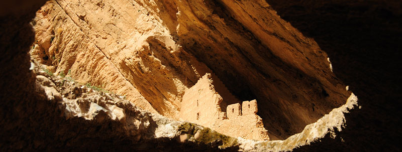
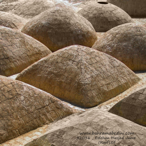
مسجد جامع ریجاب یکی از آثار باستانی و ارزشمند در استان کرمانشاه، ایران، است. این مسجد در نزدیکی روستای ریجاب و در شهرستان دالاهو قرار دارد و یکی از بناهای تاریخی مربوط به دوران صدر اسلام به شمار میآید. معماری این مسجد ترکیبی از سادگی و زیبایی خاص معماری اسلامی اولیه است.
این مسجد به خاطر ویژگیهای معماری و قدمتش، جزو میراث فرهنگی ایران محسوب میشود. از جمله ویژگیهای جالب آن میتوان به مصالح استفادهشده مانند سنگ و گل، و همچنین ایوانها و قوسهای ساده اما تأثیرگذار اشاره کرد. محوطه اطراف این مسجد نیز فضای زیبا و آرامبخشی دارد که بازدید از آن را لذتبخشتر میکند.
Farsi Description:
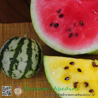
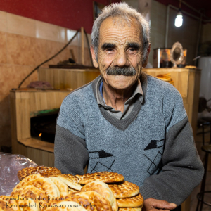
کلوچه فومن یکی از شیرینیهای سنتی و محبوب ایرانی است که اصالتاً متعلق به شهر فومن در استان گیلان میباشد. این کلوچه از دو لایه تشکیل شده است: لایه بیرونی که از خمیر نرم و لطیف تهیه میشود و لایه داخلی که حاوی مغز گردو، دارچین، هل، و شکر است. روی کلوچه با مهرهای مخصوصی نقش میزنند که به آن زیبایی خاصی میبخشد. کلوچه فومن به دلیل طعم بینظیر و عطر دلپذیرش، به عنوان یکی از سوغاتهای معروف گیلان شناخته میشود و طرفداران زیادی دارد. این شیرینی خوشمزه معمولاً در کنار چای سرو میشود و تجربهای لذتبخش را برای علاقهمندان به شیرینیهای سنتی ایرانی فراهم میکند.
به این عکس امتیاز دهید.
این عکس توسط بهرام عابدینی از تپه ها و طبیعت اطراف این منطقه گرفته شده است. برای خرید این عکس یا عکس های دیگر از طریق وبسایت یا تلفن با ما تماس بگیرید.
توضیحات انگلیسی:
Sure! Fuman cookie is a traditional and popular Iranian pastry originally from the city of Fuman in Gilan province. This cookie consists of two layers: an outer layer made of soft and delicate dough, and an inner layer filled with a mixture of walnuts, cinnamon, cardamom, and sugar. The top of the cookie is often decorated with special stamps, giving it a unique and beautiful appearance. Fuman cookie is renowned for its exceptional taste and pleasant aroma, making it a famous souvenir from Gilan with many fans. This delicious pastry is usually served with tea, providing a delightful experience for those who enjoy traditional Iranian sweets.
Please rate this picture.
This picture is taken by Bahram Abedini. If you want to purchase this picture or any other around this area please contact us through website, email or phone.
We sell pictures digitally in Large format and internationally through secure paypal payment in the US.
Farsi Description:
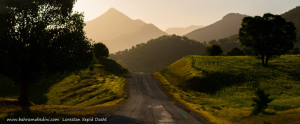
سپید دشت یکی از مناطق زیبا و دیدنی استان لرستان در ایران است. این منطقه به خاطر طبیعت بکر و مناظر طبیعی خیرهکنندهاش شناخته میشود. سپید دشت دارای کوهها، جنگلها و رودخانههای فراوانی است که آن را به مقصدی محبوب برای طبیعتگردان و علاقهمندان به ماجراجویی تبدیل کرده است. همچنین، این منطقه دارای آب و هوای معتدل و دلپذیری است که در فصول مختلف سال جذابیت خاصی به آن میبخشد.
به این عکس امتیاز دهید.
این عکس توسط بهرام عابدینی از تپه ها و طبیعت اطراف این منطقه گرفته شده است. برای خرید این عکس یا عکس های دیگر از طریق وبسایت یا تلفن با ما تماس بگیرید.
توضیحات انگلیسی:
Sepid Dasht is one of the beautiful and scenic areas in Lorestan province, Iran. This region is known for its pristine nature and stunning landscapes. Sepid Dasht features mountains, forests, and numerous rivers, making it a popular destination for nature enthusiasts and adventure seekers. Additionally, the area enjoys a mild and pleasant climate, adding to its charm throughout the year.
Please rate this picture.
This picture is taken by Bahram Abedini. If you want to purchase this picture or any other around this area please contact us through website, email or phone.
Farsi Description:
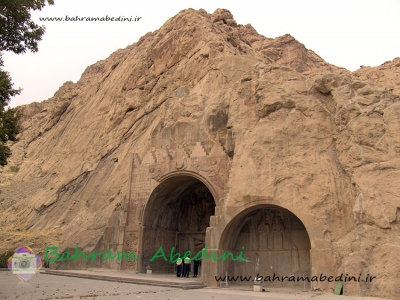
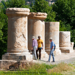
معبد آناهیتا در شهر کنگاور، استان کرمانشاه، یکی از بزرگترین بناهای سنگی ایران پس از تخت جمشید است. این معبد به الهه آناهیتا، نگهبان آب، فراوانی، زیبایی و باروری اختصاص دارد. قدمت این بنا به دورههای هخامنشیان، اشکانیان و ساسانیان بازمیگردد.
این معبد بر روی تپهای طبیعی با ارتفاع حدود ۳۲ متر ساخته شده و مساحتی حدود ۶.۴ هکتار دارد. معماری آن شامل ستونهای سنگی با ارتفاع ۵.۴۲ متر و پلکانهای دوطرفه است که به ورودی بنا منتهی میشوند.
توریستهای خارجی که به معبد آناهیتا میآیند، اغلب به دلیل اهمیت تاریخی و معماری منحصر به فرد آن جذب میشوند. این معبد به عنوان یکی از نخستین آثار ملی ایران ثبت شده و در فهرست موقت میراث جهانی یونسکو نیز قرار دارد. بازدید از این مکان به علاقهمندان به تاریخ، معماری و فرهنگ باستانی ایران توصیه میشود.
به این عکس امتیاز دهید.
این عکس توسط بهرام عابدینی از تپه ها و طبیعت اطراف این منطقه گرفته شده است. برای خرید این عکس یا عکس های دیگر از طریق وبسایت یا تلفن با ما تماس بگیرید.
توضیحات انگلیسی:
The Anahita Temple, located in Kangavar, Kermanshah province, is one of the largest stone structures in Iran after Persepolis. This temple is dedicated to the goddess Anahita, the guardian of water, abundance, beauty, and fertility. Its construction dates back to the Achaemenid, Parthian, and Sassanian periods.
The temple is built on a natural hill with a height of about 32 meters and covers an area of approximately 6.4 hectares. Its architecture includes stone columns with a height of 5.42 meters and double staircases leading to the entrance.
Foreign tourists visiting the Anahita Temple are often attracted by its historical significance and unique architecture. The temple is registered as one of Iran's earliest national monuments and is also on the UNESCO World Heritage Tentative List. Visiting this site is recommended for those interested in the history, architecture, and ancient culture of Iran.
Please rate this picture.
This picture is taken by Bahram Abedini. If you want to purchase this picture or any other around this area please contact us through website, email or phone.
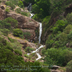
Farsi Description:
آبشار چم چیت، که به نام آبشار آبگرمه نیز شناخته میشود، یکی از جاذبههای طبیعی زیبا در استان لرستان است. این آبشار در نزدیکی روستای چم چیت و در مسیر رودخانه سزار قرار دارد.
آبشار چم چیت با ارتفاع بیش از ۲۰ متر و عرض تاج ۱۰ متر، در میان پوششهای گیاهی متراکم و طبیعت بکر منطقه جاری است. این آبشار به دلیل نزدیکی به آبشار مشهور بیشه کمتر شناخته شده است، اما زیبایی خاص خود را دارد و در تمام فصول سال جذابیتهای ویژهای ارائه میدهد.
برای رسیدن به این آبشار، میتوانید از مسیرهای ریلی و آسفالته استفاده کنید. مسیر ریلی از راهآهن تهران-خوزستان و بین ایستگاههای قارون و بیشه میگذرد.
به این عکس امتیاز دهید.
این عکس توسط بهرام عابدینی از تپه ها و طبیعت اطراف این منطقه گرفته شده است. برای خرید این عکس یا عکس های دیگر از طریق وبسایت یا تلفن با ما تماس بگیرید.
توضیحات انگلیسی:
Cham Chit Waterfall, also known as Abgarmeh Waterfall, is one of the beautiful natural attractions in Lorestan Province. This waterfall is located near the village of Cham Chit and along the Sezar River.
Cham Chit Waterfall, with a height of over 20 meters and a crown width of 10 meters, flows amidst dense vegetation and pristine nature. Due to its proximity to the famous Bisheh Waterfall, it is less known but has its own unique beauty and offers special attractions in all seasons.
To reach this waterfall, you can use both rail and asphalt routes. The rail route passes through the Tehran-Khuzestan railway and between the stations of Qarun and Bisheh.
Please rate this picture.
This picture is taken by Bahram Abedini. If you want to purchase this picture or any other around this area please contact us through website, email or phone.
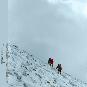
Farsi Description:
قله هفت خوان یکی از قلل زیبای رشتهکوه البرز غربی است که در نزدیکی روستای سپهسالار قرار دارد و ارتفاع آن به ۳۹۷۰ متر میرسد. در زمستان سال ۱۳۵۹، صعود به این قله به دلیل شرایط سخت آب و هوایی و برف سنگین، چالشی بزرگ برای کوهنوردان بود.
در آن سال، گروهی از کوهنوردان با تجهیزات محدود و بدون امکانات پیشرفته امروزی، تصمیم به صعود به قله هفت خوان گرفتند. مسیر صعود از روستای سپهسالار آغاز شد و کوهنوردان با عبور از یال جنوبی و گردنه خرگوش، به سمت قله حرکت کردند. شرایط سخت زمستانی، از جمله برف سنگین و بادهای شدید، این صعود را بسیار دشوار کرد.
با وجود این چالشها، کوهنوردان با تلاش و پشتکار فراوان توانستند به قله برسند و این صعود به عنوان یکی از دستاوردهای مهم کوهنوردی در آن زمان به شمار میرفت. این صعود نشاندهنده اراده و عزم راسخ کوهنوردان در مواجهه با شرایط سخت طبیعی بود.
به این عکس امتیاز دهید.
این عکس توسط بهرام عابدینی از تپه ها و طبیعت اطراف این منطقه گرفته شده است. برای خرید این عکس یا عکس های دیگر از طریق وبسایت یا تلفن با ما تماس بگیرید.
توضیحات انگلیسی:
Mount Haft Khān is one of the beautiful peaks of the western Alborz mountain range, located near the village of Sepahsalar, with an elevation of 3,970 meters (13,024.93 feet.). In the winter of 1980, climbing this peak was a significant challenge for mountaineers due to harsh weather conditions and heavy snowfall.
That year, a group of mountaineers, with limited equipment and without the advanced facilities available today, decided to climb Mount Haft Khān. The ascent route started from the village of Sepahsalar, and the climbers moved towards the peak by passing through the southern ridge and Kharghosh Pass. The harsh winter conditions, including heavy snow and strong winds, made this climb very difficult.
Despite these challenges, the mountaineers, with great effort and perseverance, managed to reach the summit. This climb was considered one of the significant achievements in mountaineering at that time. It demonstrated the determination and strong will of mountaineers in facing tough natural conditions.
Please rate this picture.
This picture is taken by Bahram Abedini. If you want to purchase this picture or any other around this area please contact us through website, email or phone.