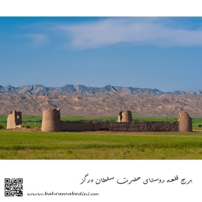
")
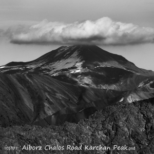
عکس سیاه و سفید از کوه
Farsi Description:
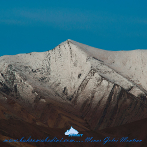
قلهٔ کرچان در رشتهکوه البرز مرکزی واقع شده و یکی از قلههای محبوب کوهنوردان است. این قله با ارتفاعی حدود ۳۹۰۰ متر (بسته به مسیر اندازهگیری) چشماندازی وسیع به دشت هراز، قلههای دماوند و منطقهٔ پلور دارد. مسیرهای صعود معمولاً از روستاهای نوا یا پلور آغاز میشود و به دلیل مناظر بکر، سکوت کوهستان و نزدیکی به تهران مقصدی جذاب برای صعود یکروزه یا دوروزه است.
به این عکس امتیاز دهید.
این عکس توسط بهرام عابدینی از تپه ها و طبیعت اطراف این منطقه گرفته شده است. برای خرید این عکس یا عکس های دیگر از طریق وبسایت یا تلفن با ما تماس بگیرید.
توضیحات انگلیسی:
Karchan Peak is located in the Central Alborz mountain range and is a popular destination for climbers. Standing at an elevation of about 3,900 m, it offers wide, breathtaking views of the Haraz plain, Mount Damavand, and the surrounding Plour region. The usual ascent routes start from the villages of Nava or Plour, making it an attractive choice for a one-day or two-day climb thanks to its pristine landscapes, peaceful mountain atmosphere, and convenient access from Tehran.
Please rate this picture.
This picture is taken by Bahram Abedini. If you want to purchase this picture or any other around this area please contact us through website, email or phone.
We sell pictures digitally in Large format and internationally through secure paypal payment in the US.
کوه های البرز: قله منار و گلوی
Farsi Description:
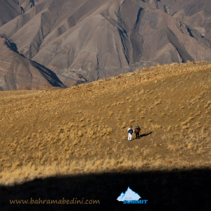
قله منا ر و گلوی به ارتفاع تقریبی سه وهزارو پانصد متر در شمال روستای واریان وجنوب شرقی روستای مورودقرار دارد این دوقله در خطالراس سیاه سنگ منار و گلوی و گلو سربند واقع است راه صعود به قله بیشتر از روستای مورود است آبشار های که از قله ها سرازیر می شود یکی آبشا ر چهار صد تنور در جنوب و آبشار رفک در شمال این کوه قرار دارد.
به این عکس امتیاز دهید.
این عکس توسط بهرام عابدینی از تپه ها و طبیعت اطراف این منطقه گرفته شده است. برای خرید این عکس یا عکس های دیگر از طریق وبسایت یا تلفن با ما تماس بگیرید.
توضیحات انگلیسی:
Please rate this picture.
The peaks of Manar and Golou, with an approximate height of 3,500 meters, are located north of the village of Varyan and southeast of the village of Moroud. These two peaks are situated on the ridge of Siah Sang Manar and Golou and Golou Sarband. The main route to ascend the peaks is from the village of Moroud. The waterfalls that flow from the peaks include the Four Hundred Tanur waterfall in the south and the Rafak waterfall in the north of this mountain."
This picture is taken by Bahram Abedini. If you want to purchase this picture or any other around this area please contact us through website, email or phone.
We sell pictures digitally in Large format and internationally through secure paypal payment in the US.
معرفی کوه های البرز قله پورا
Farsi Description:
قله پورا از جنوب به روستای کندر ، از شمال به روستای ابهرک و ارنگه ، از غرب به روستای آدران و از شرق بر روی خط الراس قلل چال ، سیوچال ، درزو و پشته بند محراب چشمه شاهی قله پهنه سار امتداد دارد مسیرهای صعود جاده قدیم کندور دره گلنا و آبشار نمرک و روستای ابهرک ارتغاع قله دوهزارو نصد متر است
به این عکس امتیاز دهید.
این عکس توسط بهرام عابدینی از تپه ها و طبیعت اطراف این منطقه گرفته شده است. برای خرید این عکس یا عکس های دیگر از طریق وبسایت یا تلفن با ما تماس بگیرید.
توضیحات انگلیسی:
Pura Peak is bordered to the south by the village of Kondor, to the north by the villages of Abharak and Arangeh, to the west by the village of Adran, and to the east along the ridge line of Chal, Sivchal, Darzu, and Pusht-e Band Mehrab Cheshmeh Shahi peaks, extending to Pahne Sar Peak. The ascent routes include the old Kondor Road, Golna Valley, Namrak Waterfall, and the village of Abharak. The peak's elevation is 2,900 meters.
Please rate this picture.
This picture is taken by Bahram Abedini. If you want to purchase this picture or any other around this area please contact us through website, email or phone.
We sell pictures digitally in Large format and internationally through secure paypal payment in the US.
قله چشمه شاهی
Farsi Description:
قله چشمه شاهی به ارتفاع سه هزارو دویست و هشتاد متر این کوه در شمال غرب تهران واقع شده است. در شرق این قله روستای سنگان، در جنوب شرقی آن روستای کشار علیا، در غرب روستای چاران و آبشار زیبای چاران و در شمال غربی آن روستای خور و در شمال قله پهنه حصار واقع شده است که در حقیقت با قله پهنه حصار و قله بارو یال مشترک دارد قله چشمه شاهی در نقشه ها جزو استان تهران میباشد ولی جزو حوزه آبریز رودخانه کرج هست آبشارهای که از این کوه به پائین می ریزد عبارت از آبشار خور -_ چاران _ کندور _ ده سر _ سکوت یزدان _ سر تنگه _ آرزوها _
به این عکس امتیاز دهید.
این عکس توسط بهرام عابدینی از تپه ها و طبیعت اطراف این منطقه گرفته شده است. برای خرید این عکس یا عکس های دیگر از طریق وبسایت یا تلفن با ما تماس بگیرید.
توضیحات انگلیسی:
Cheshmeh Shahi Peak, with an elevation of 3,280 meters, is located in the northwest of Tehran. To the east of this peak is the village of Sangan, to the southeast is the village of Keshar Aliya, to the west is the village of Charan and the beautiful Charan Waterfall, and to the northwest is the village of Khor. To the north of the peak is Pahneh Hesar, which shares a ridge with Baro Peak. Although Cheshmeh Shahi Peak is marked as part of Tehran province on maps, it belongs to the Karaj River watershed. The waterfalls descending from this mountain include Khor Waterfall, Charan Waterfall, Kondor Waterfall, Deh Sar Waterfall, Sokut Yazdan Waterfall, Sar Tange Waterfall, and Arezuha Waterfall.
Please rate this picture.
This picture is taken by Bahram Abedini. If you want to purchase this picture or any other around this area please contact us through website, email or phone.
We sell pictures digitally in Large format and internationally through secure paypal payment in the US.
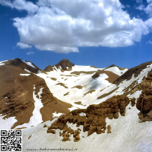
کوه برفی قله چال
Farsi Description:
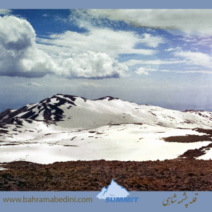
قله چال یکی از قلههای زیبای البرز مرکزی است که با ارتفاع ۲۹۱۸ متر در شمال روستای کندور و جنوب روستای چاران قرار دارد. این قله در خط الراس قله پورا به پهنه حصار واقع شده است. مسیرهای معمول صعود به قله چال شامل روستای چاران، ابهرک، سرزیارت و کندور میباشد.
این منطقه با طبیعت بکر و چشماندازهای خیرهکنندهاش، مقصدی محبوب برای کوهنوردان و طبیعتگردان است. عکسهایی که از روی قله پیله گرفته شدهاند، زیباییهای این منطقه را به خوبی نشان میدهند.
به این عکس امتیاز دهید.
این عکس توسط بهرام عابدینی از تپه ها و طبیعت اطراف این منطقه گرفته شده است. برای خرید این عکس یا عکس های دیگر از طریق وبسایت یا تلفن با ما تماس بگیرید.
توضیحات انگلیسی:
Chal Peak is one of the beautiful peaks of the Central Alborz range, standing at an elevation of 2,918 meters. It is located north of the village of Kondor and south of the village of Charan, along the ridge from Pura Peak to Pahneh Hesar. The common routes for ascending Chal Peak include Charan, Abharak, Sarziarat, and Kondor.
This area is a popular destination for hikers and nature enthusiasts due to its pristine nature and stunning landscapes. Photos taken from the summit of Pileh Peak showcase the beauty of this region.
Please rate this picture.
This picture is taken by Bahram Abedini. If you want to purchase this picture or any other around this area please contact us through website, email or phone.
We sell pictures digitally in Large format and internationally through secure paypal payment in the US.
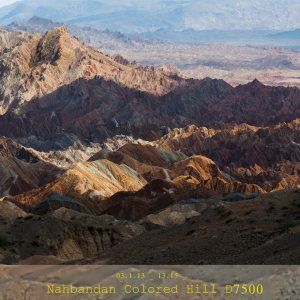
عکس کوه های مریخی خراسان اثر بهرام عابدینی
Farsi Description:
کوههای مریخی نهبندان، که به کوههای مینیاتوری نیز معروف هستند، در نزدیکی شهر نهبندان در استان خراسان جنوبی قرار دارند. این کوهها به دلیل شکلهای غیرعادی خود شبیه به سطح مریخ به نظر میرسند و یکی از جاذبههای طبیعی منطقه محسوب میشوند.
به این عکس امتیاز دهید.
این عکس توسط بهرام عابدینی از تپه ها و طبیعت اطراف این منطقه گرفته شده است. برای خرید این عکس یا عکس های دیگر از طریق وبسایت یا تلفن با ما تماس بگیرید.
توضیحات انگلیسی:
The Martian Mountains of Nehbandan, also known as the Miniature Mountains, are located near the city of Nehbandan in South Khorasan Province. These mountains resemble the surface of Mars due to their unusual and jagged shapes, making them a unique natural attraction in the region.
Please rate this picture.
This picture is taken by Bahram Abedini. If you want to purchase this picture or any other around this area please contact us through website, email or phone.
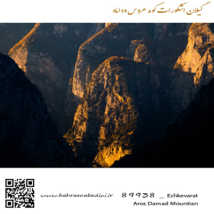
کوه عروس و داماد در گیلان
Farsi Description:
کوه عروس و داماد در منطقه اشکورات گیلان و نزدیک روستای زیاز قرار دارد. این کوه به دلیل وجود دو مجسمه سنگی به شکل عروس و داماد معروف است. طبق افسانههای محلی، این مجسمهها نماد یک زوج عاشق هستند که به دلیل مخالفت خانوادهها به سنگ تبدیل شدند.
به این عکس امتیاز دهید.
این عکس توسط بهرام عابدینی از تپه ها و طبیعت اطراف این منطقه گرفته شده است. برای خرید این عکس یا عکس های دیگر از طریق وبسایت یا تلفن با ما تماس بگیرید.
توضیحات انگلیسی:
Bride and Groom Mountain (Aroos va Doomad Kooh) is located in the Ashkorat region of Gilan, near the village of Ziaz. This mountain is famous for two stone statues resembling a bride and groom. According to local legends, these statues represent a couple who turned to stone due to family opposition to their love.
Please rate this picture.
This picture is taken by Bahram Abedini. If you want to purchase this picture or any other around this area please contact us through website, email or phone.
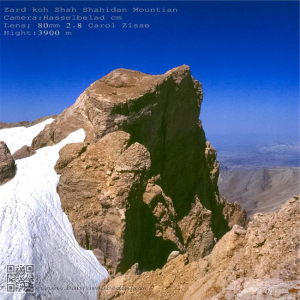
کوه شاه شهیدان
Farsi Description:
کوه شاه شهیدان در رشتهکوه زاگرس بختیاری و استان چهارمحال و بختیاری با ارتفاع ۴۲۲۱ متر قرار دارد. این کوه یکی از بلندترین قلل منطقه است و به دلیل مناظر طبیعی زیبا و مسیرهای چالشبرانگیز، مقصدی محبوب برای کوهنوردان حرفهای است.
نام این کوه نباید با کوه دیگری دقیقا با همین نام در استان گیلان اشتباه شود.
به این عکس امتیاز دهید.
این عکس توسط بهرام عابدینی از تپه ها و طبیعت اطراف این منطقه گرفته شده است. برای خرید این عکس یا عکس های دیگر از طریق وبسایت یا تلفن با ما تماس بگیرید.
توضیحات انگلیسی:
Shah Shahidan Mountain in the Zagros Bakhtiari range, located in Chaharmahal and Bakhtiari Province, stands at 4,221 meters. It’s one of the highest peaks in the region and a popular destination for professional climbers due to its beautiful natural scenery and challenging routes.
This mountain should not be confused with the other mountain with the same name in the province of Gilan.
Please rate this picture.
This picture is taken by Bahram Abedini. If you want to purchase this picture or any other around this area please contact us through website, email or phone.
قله کلونچی (زردکوه)
Farsi description:
قله کلونچی با ارتفاع ۴۲۲۱ متر بلندترین قله رشتهکوه زردکوه بختیاری در استان چهارمحال و بختیاری است. این قله دومین کوه مرتفع در رشتهکوههای زاگرس است و صعود به آن از مسیر تنگه کول خدنگ انجام میشود.
به این عکس امتیاز دهید.
این عکس توسط بهرام عابدینی از تپه ها و طبیعت اطراف این منطقه گرفته شده است. برای خرید این عکس یا عکس های دیگر از طریق وبسایت یا تلفن با ما تماس بگیرید.
توضیحات انگلیسی:
Kolonchi Peak (or Kolonchi) stands at an elevation of 4,221 meters, making it the highest peak in the Zardkuh Bakhtiari mountain range in Chaharmahal and Bakhtiari Province. It is the second highest mountain in the Zagros range and a favorite among professional climbers. The ascent typically starts from the Kol Khodang Gorge.
Please rate this picture.
This picture is taken by Bahram Abedini. If you want to purchase this picture or any other around this area please contact us through website, email or phone.
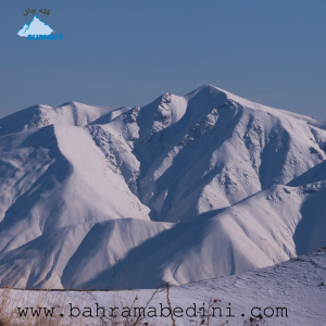
قله توچال بهمن ماه 1364
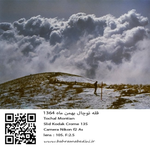
عکسی از قله توچال در سال 1364 در ماه بهمن
مشخصات دوربین و لنز در زیر عکس ذکر شده است.
به این عکس امتیاز دهید.
این عکس توسط بهرام عابدینی از تپه ها و طبیعت اطراف این منطقه گرفته شده است. برای خرید این عکس یا عکس های دیگر از طریق وبسایت یا تلفن با ما تماس بگیرید.
English description:
In 1985, Tochal Mountain in Iran, part of the Alborz range, was a popular destination for its stunning views and rugged terrain. Standing at 3,963 meters, it featured various peaks and trails for hikers and climbers. The Tochal Telecabin, a gondola lift, provided easy access to higher altitudes and the ski resort. The mountain’s proximity to Tehran made it a quick escape for outdoor enthusiasts, with shelters like Shirpala and Siahsang offering rest stops. Overall, Tochal was a cherished natural landmark blending adventure and tranquility.
Please rate this picture.
This picture is taken by Bahram Abedini. If you want to purchase this picture or any other around this area please contact us through website, email or phone.