")
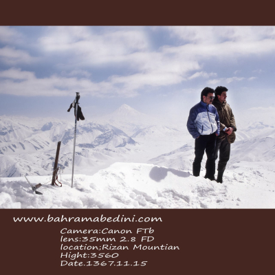
عکس سیاه و سفید از کوه
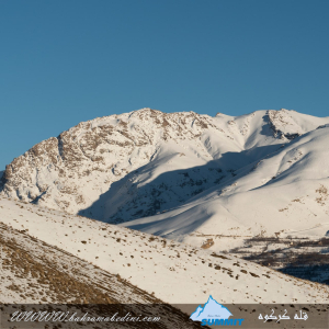
Farsi Description:
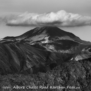
قلهٔ کرچان در رشتهکوه البرز مرکزی واقع شده و یکی از قلههای محبوب کوهنوردان است. این قله با ارتفاعی حدود ۳۹۰۰ متر (بسته به مسیر اندازهگیری) چشماندازی وسیع به دشت هراز، قلههای دماوند و منطقهٔ پلور دارد. مسیرهای صعود معمولاً از روستاهای نوا یا پلور آغاز میشود و به دلیل مناظر بکر، سکوت کوهستان و نزدیکی به تهران مقصدی جذاب برای صعود یکروزه یا دوروزه است.
به این عکس امتیاز دهید.
این عکس توسط بهرام عابدینی از تپه ها و طبیعت اطراف این منطقه گرفته شده است. برای خرید این عکس یا عکس های دیگر از طریق وبسایت یا تلفن با ما تماس بگیرید.
توضیحات انگلیسی:
Karchan Peak is located in the Central Alborz mountain range and is a popular destination for climbers. Standing at an elevation of about 3,900 m, it offers wide, breathtaking views of the Haraz plain, Mount Damavand, and the surrounding Plour region. The usual ascent routes start from the villages of Nava or Plour, making it an attractive choice for a one-day or two-day climb thanks to its pristine landscapes, peaceful mountain atmosphere, and convenient access from Tehran.
Please rate this picture.
This picture is taken by Bahram Abedini. If you want to purchase this picture or any other around this area please contact us through website, email or phone.
We sell pictures digitally in Large format and internationally through secure paypal payment in the US.
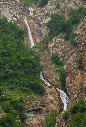
آبشار آندرس در مازندران
Farsi Description:
آبشار آندرس مجموعه ای در حدود 50 آبشار پشت سر هم است که در طبقه بندی آبشارها آبشار پله ای طبقه بندی میشود که در این رابطه میتوانید کتاب بنده "آبشارهای استان البرز" بیشتر مطالعه کنید. این آبشار از سیاه بیشه قابل روئت است. این آبشار بر روی کوه آرنگ چال قرار دارد.
به این عکس امتیاز دهید.
این عکس توسط بهرام عابدینی از تپه ها و طبیعت اطراف این منطقه گرفته شده است. برای خرید این عکس یا عکس های دیگر از طریق وبسایت یا تلفن با ما تماس بگیرید.
توضیحات انگلیسی:
Anders Waterfall is a series of approximately 50 consecutive waterfalls, which classifies it as a stepped or tiered waterfall. For more information on this type of waterfall, you can refer to my book "The Waterfalls of Alborz Province." This waterfall is visible from Siah Bisheh and is located on Mount Arang Chal.
Waterfalls cascading down from mountains are among the most breathtaking natural phenomena on Earth. They form when rivers or streams, fed by melting snow or rain from high elevations, plunge dramatically over rocky cliffs and steep terrain. As the water descends, it carves through stone, creating misty veils, thunderous sounds, and glistening pools below.
These mountain waterfalls are often tucked within lush forests or rugged alpine landscapes, offering moments of serene beauty and raw power. Their presence not only enhances the visual splendor of mountainous regions but also supports diverse ecosystems, providing moisture and habitat for plants and animals.
Symbolically, mountain waterfalls often represent purity, renewal, and the relentless energy of nature—always flowing, shaping, and giving life. Whether a gentle trickle or a roaring cascade, they remind us of the majesty and movement of the natural world.
Please rate this picture.
This picture is taken by Bahram Abedini. If you want to purchase this picture or any other around this area please contact us through website, email or phone.
We sell pictures digitally in Large format and internationally through secure paypal payment in the US.
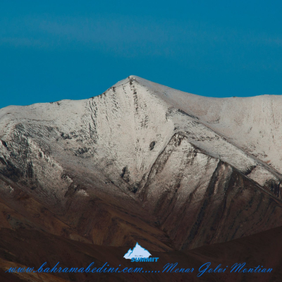
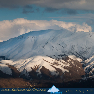
کوه های البرز: قله منار و گلوی

Farsi Description:
قله منا ر و گلوی به ارتفاع تقریبی سه وهزارو پانصد متر در شمال روستای واریان وجنوب شرقی روستای مورودقرار دارد این دوقله در خطالراس سیاه سنگ منار و گلوی و گلو سربند واقع است راه صعود به قله بیشتر از روستای مورود است آبشار های که از قله ها سرازیر می شود یکی آبشا ر چهار صد تنور در جنوب و آبشار رفک در شمال این کوه قرار دارد.
به این عکس امتیاز دهید.
این عکس توسط بهرام عابدینی از تپه ها و طبیعت اطراف این منطقه گرفته شده است. برای خرید این عکس یا عکس های دیگر از طریق وبسایت یا تلفن با ما تماس بگیرید.
توضیحات انگلیسی:
Please rate this picture.
The peaks of Manar and Golou, with an approximate height of 3,500 meters, are located north of the village of Varyan and southeast of the village of Moroud. These two peaks are situated on the ridge of Siah Sang Manar and Golou and Golou Sarband. The main route to ascend the peaks is from the village of Moroud. The waterfalls that flow from the peaks include the Four Hundred Tanur waterfall in the south and the Rafak waterfall in the north of this mountain."
This picture is taken by Bahram Abedini. If you want to purchase this picture or any other around this area please contact us through website, email or phone.
We sell pictures digitally in Large format and internationally through secure paypal payment in the US.
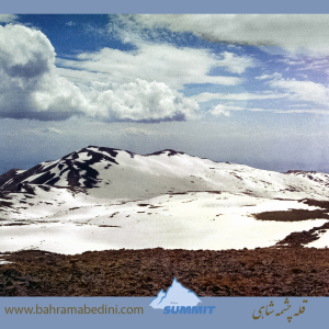
کوه های البرز: کرکوه
Farsi Description:
قلهٔ کرکوه با ارتفاع ۳۱۰۰ متر در درهٔ خور و سیجان واقع شده است. این قله با قلههای پهنهحصار و چال ناجی یال مشترک دارد و آبشارهای زیبای پنجهپلنگ و رفک در دامنههای آن قرار گرفتهاند. منطقهٔ کرکوه با طبیعت بکر، پوشش گیاهی متنوع و چشماندازهای کوهستانی، یکی از مقاصد محبوب کوهنوردان و طبیعتگردان در نزدیکی تهران به شمار میرود.
به این عکس امتیاز دهید.
این عکس توسط بهرام عابدینی از تپه ها و طبیعت اطراف این منطقه گرفته شده است. برای خرید این عکس یا عکس های دیگر از طریق وبسایت یا تلفن با ما تماس بگیرید.
توضیحات انگلیسی:
Mount Karkouh, standing at an elevation of 3,100 meters, is located in the Khur and Sijan valley. It shares a ridge with the peaks of Pahneh Hisar and Chal Naji, and the beautiful waterfalls of Panjeh Palang and Rafak lie at its base. The Karkouh region, with its pristine nature, diverse vegetation, and stunning mountain landscapes, is a popular destination for hikers and nature enthusiasts near Tehran.
Please rate this picture.
This picture is taken by Bahram Abedini. If you want to purchase this picture or any other around this area please contact us through website, email or phone.
We sell pictures digitally in Large format and internationally through secure paypal payment in the US.
قله پهنه حصار به ارتفاع 3250 متر
Farsi Description:
کوه پهنه حصار یک قله برجسته در کوههای البرز مرکزی در شمال ایران، نزدیک روستای سنگان بالا است. این کوه به خاطر مسیرهای دیدنی، مناظر متنوع و تنوع زیستی غنی خود شناخته شده است. این منطقه شامل آبشار چشمگیر سنگان نیز میشود که آن را به مقصدی محبوب برای کوهنوردان و علاقهمندان به طبیعت تبدیل کرده است.
به این عکس امتیاز دهید.
این عکس توسط بهرام عابدینی از تپه ها و طبیعت اطراف این منطقه گرفته شده است. برای خرید این عکس یا عکس های دیگر از طریق وبسایت یا تلفن با ما تماس بگیرید.
توضیحات انگلیسی:
The Mountain of Pahne Hesar is a prominent peak in the Central Alborz Mountains of northern Iran, near the village of Sangan Bala. It's known for its scenic trails, diverse landscapes, and rich biodiversity. The area includes the impressive Sangan Waterfall, making it a popular destination for hikers and nature enthusiasts.
Please rate this picture.
This picture is taken by Bahram Abedini. If you want to purchase this picture or any other around this area please contact us through website, email or phone.
We sell pictures digitally in Large format and internationally through secure paypal payment in the US.
قله چشمه شاهی
Farsi Description:
قله چشمه شاهی به ارتفاع سه هزارو دویست و هشتاد متر این کوه در شمال غرب تهران واقع شده است. در شرق این قله روستای سنگان، در جنوب شرقی آن روستای کشار علیا، در غرب روستای چاران و آبشار زیبای چاران و در شمال غربی آن روستای خور و در شمال قله پهنه حصار واقع شده است که در حقیقت با قله پهنه حصار و قله بارو یال مشترک دارد قله چشمه شاهی در نقشه ها جزو استان تهران میباشد ولی جزو حوزه آبریز رودخانه کرج هست آبشارهای که از این کوه به پائین می ریزد عبارت از آبشار خور -_ چاران _ کندور _ ده سر _ سکوت یزدان _ سر تنگه _ آرزوها _
به این عکس امتیاز دهید.
این عکس توسط بهرام عابدینی از تپه ها و طبیعت اطراف این منطقه گرفته شده است. برای خرید این عکس یا عکس های دیگر از طریق وبسایت یا تلفن با ما تماس بگیرید.
توضیحات انگلیسی:
Cheshmeh Shahi Peak, with an elevation of 3,280 meters, is located in the northwest of Tehran. To the east of this peak is the village of Sangan, to the southeast is the village of Keshar Aliya, to the west is the village of Charan and the beautiful Charan Waterfall, and to the northwest is the village of Khor. To the north of the peak is Pahneh Hesar, which shares a ridge with Baro Peak. Although Cheshmeh Shahi Peak is marked as part of Tehran province on maps, it belongs to the Karaj River watershed. The waterfalls descending from this mountain include Khor Waterfall, Charan Waterfall, Kondor Waterfall, Deh Sar Waterfall, Sokut Yazdan Waterfall, Sar Tange Waterfall, and Arezuha Waterfall.
Please rate this picture.
This picture is taken by Bahram Abedini. If you want to purchase this picture or any other around this area please contact us through website, email or phone.
We sell pictures digitally in Large format and internationally through secure paypal payment in the US.
مرد کلوچه فروش
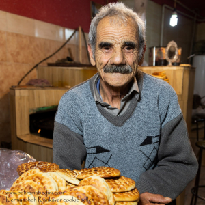
Farsi Description:
کلوچه فومن یکی از شیرینیهای سنتی و محبوب ایرانی است که اصالتاً متعلق به شهر فومن در استان گیلان میباشد. این کلوچه از دو لایه تشکیل شده است: لایه بیرونی که از خمیر نرم و لطیف تهیه میشود و لایه داخلی که حاوی مغز گردو، دارچین، هل، و شکر است. روی کلوچه با مهرهای مخصوصی نقش میزنند که به آن زیبایی خاصی میبخشد. کلوچه فومن به دلیل طعم بینظیر و عطر دلپذیرش، به عنوان یکی از سوغاتهای معروف گیلان شناخته میشود و طرفداران زیادی دارد. این شیرینی خوشمزه معمولاً در کنار چای سرو میشود و تجربهای لذتبخش را برای علاقهمندان به شیرینیهای سنتی ایرانی فراهم میکند.
به این عکس امتیاز دهید.
این عکس توسط بهرام عابدینی از تپه ها و طبیعت اطراف این منطقه گرفته شده است. برای خرید این عکس یا عکس های دیگر از طریق وبسایت یا تلفن با ما تماس بگیرید.
توضیحات انگلیسی:
Sure! Fuman cookie is a traditional and popular Iranian pastry originally from the city of Fuman in Gilan province. This cookie consists of two layers: an outer layer made of soft and delicate dough, and an inner layer filled with a mixture of walnuts, cinnamon, cardamom, and sugar. The top of the cookie is often decorated with special stamps, giving it a unique and beautiful appearance. Fuman cookie is renowned for its exceptional taste and pleasant aroma, making it a famous souvenir from Gilan with many fans. This delicious pastry is usually served with tea, providing a delightful experience for those who enjoy traditional Iranian sweets.
Please rate this picture.
This picture is taken by Bahram Abedini. If you want to purchase this picture or any other around this area please contact us through website, email or phone.
We sell pictures digitally in Large format and internationally through secure paypal payment in the US.
سپید دشت لرستان
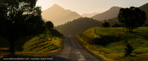
Farsi Description:
سپید دشت یکی از مناطق زیبا و دیدنی استان لرستان در ایران است. این منطقه به خاطر طبیعت بکر و مناظر طبیعی خیرهکنندهاش شناخته میشود. سپید دشت دارای کوهها، جنگلها و رودخانههای فراوانی است که آن را به مقصدی محبوب برای طبیعتگردان و علاقهمندان به ماجراجویی تبدیل کرده است. همچنین، این منطقه دارای آب و هوای معتدل و دلپذیری است که در فصول مختلف سال جذابیت خاصی به آن میبخشد.
به این عکس امتیاز دهید.
این عکس توسط بهرام عابدینی از تپه ها و طبیعت اطراف این منطقه گرفته شده است. برای خرید این عکس یا عکس های دیگر از طریق وبسایت یا تلفن با ما تماس بگیرید.
توضیحات انگلیسی:
Sepid Dasht is one of the beautiful and scenic areas in Lorestan province, Iran. This region is known for its pristine nature and stunning landscapes. Sepid Dasht features mountains, forests, and numerous rivers, making it a popular destination for nature enthusiasts and adventure seekers. Additionally, the area enjoys a mild and pleasant climate, adding to its charm throughout the year.
Please rate this picture.
This picture is taken by Bahram Abedini. If you want to purchase this picture or any other around this area please contact us through website, email or phone.
آبشار چم چیت
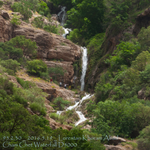
Farsi Description:
آبشار چم چیت، که به نام آبشار آبگرمه نیز شناخته میشود، یکی از جاذبههای طبیعی زیبا در استان لرستان است. این آبشار در نزدیکی روستای چم چیت و در مسیر رودخانه سزار قرار دارد.
آبشار چم چیت با ارتفاع بیش از ۲۰ متر و عرض تاج ۱۰ متر، در میان پوششهای گیاهی متراکم و طبیعت بکر منطقه جاری است. این آبشار به دلیل نزدیکی به آبشار مشهور بیشه کمتر شناخته شده است، اما زیبایی خاص خود را دارد و در تمام فصول سال جذابیتهای ویژهای ارائه میدهد.
برای رسیدن به این آبشار، میتوانید از مسیرهای ریلی و آسفالته استفاده کنید. مسیر ریلی از راهآهن تهران-خوزستان و بین ایستگاههای قارون و بیشه میگذرد.
به این عکس امتیاز دهید.
این عکس توسط بهرام عابدینی از تپه ها و طبیعت اطراف این منطقه گرفته شده است. برای خرید این عکس یا عکس های دیگر از طریق وبسایت یا تلفن با ما تماس بگیرید.
توضیحات انگلیسی:
Cham Chit Waterfall, also known as Abgarmeh Waterfall, is one of the beautiful natural attractions in Lorestan Province. This waterfall is located near the village of Cham Chit and along the Sezar River.
Cham Chit Waterfall, with a height of over 20 meters and a crown width of 10 meters, flows amidst dense vegetation and pristine nature. Due to its proximity to the famous Bisheh Waterfall, it is less known but has its own unique beauty and offers special attractions in all seasons.
To reach this waterfall, you can use both rail and asphalt routes. The rail route passes through the Tehran-Khuzestan railway and between the stations of Qarun and Bisheh.
Please rate this picture.
This picture is taken by Bahram Abedini. If you want to purchase this picture or any other around this area please contact us through website, email or phone.
جاده شهداد ، کویر لوت
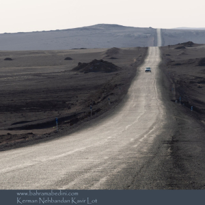
Farsi Description:
کویر لوت یکی از شگفتانگیزترین مناطق طبیعی ایران است و در فروردین 1403 میزبان گردشگران و طبیعتدوستان خواهد بود. جاده شهداد به نهبندان، که از دل این کویر میگذرد، یکی از مسیرهای محبوب برای سفر به این منطقه است.
در این سفر، میتوانید از کلوتهای شهداد بازدید کنید. کلوتها، برجستگیهای شنی عظیمی هستند که در اثر فرسایش باد و آب به وجود آمدهاند و یکی از زیباترین مناظر طبیعی ایران را تشکیل میدهند. این منطقه به دلیل زیبایی بینظیر و شرایط خاص جغرافیایی، در فهرست آثار ملی ایران و میراث جهانی یونسکو به ثبت رسیده است.
در طول این سفر، میتوانید از جاذبههای تاریخی منطقه شهداد نیز بازدید کنید و از نخلستانها و رود شور که تنها رود دائمی در اعماق کویر لوت است، دیدن کنید. همچنین، تجربه شبنشینی و رصد آسمان پرستاره کویر و بازدید از آبشار کشیت، از دیگر جاذبههای این سفر خواهد بود.
به این عکس امتیاز دهید.
این عکس توسط بهرام عابدینی از تپه ها و طبیعت اطراف این منطقه گرفته شده است. برای خرید این عکس یا عکس های دیگر از طریق وبسایت یا تلفن با ما تماس بگیرید.
توضیحات انگلیسی:
The Lut Desert, one of Iran's most astonishing natural areas, will welcome tourists and nature enthusiasts in April 2024. The road from Shahdad to Nehbandan, which passes through this desert, is a popular route for traveling to this region.
During this trip, you can visit the Shahdad Kaluts. These massive sand formations, created by wind and water erosion, are among the most beautiful natural landscapes in Iran. Due to its unique beauty and geographical conditions, this area is listed as a national heritage site in Iran and a UNESCO World Heritage site.
Throughout this journey, you can also explore the historical attractions of the Shahdad region, visit the palm groves, and see the Shur River, the only permanent river in the depths of the Lut Desert. Additionally, experiencing a night under the starry desert sky and visiting the Keshit Waterfall are other highlights of this trip.
Please rate this picture.
This picture is taken by Bahram Abedini. If you want to purchase this picture or any other around this area please contact us through website, email or phone.