Photogram
Latest photos of Iran by Bahram Abedini
Photogram
Photogram
Latest photos by Bahram Abedini
Latest photos of Iran by Bahram Abedini
Website Language

")
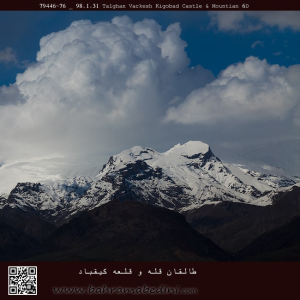
قله ی کیقباد در منطقه ی طالقان
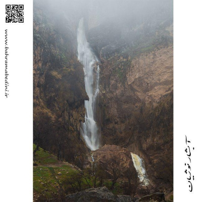
قلعه کیقباد در منتهی الیه جنوب غرب روستای ایگل و در دامنه شرقی ارتفاعاتی که نهایتا به قله توچال منتهی می شود و خانه های ده در دامنه آن واقع شده است و در موقعیت جغرافیایی 35 درجه و 54 دقیقه و 44 ثانیه عرض جغرافیایی و 51 درجه و 29 دقیقه و 2 ثانیه طول جغرافیایی و در ارتفاع 2062 متر از سطح دریا و در جبهه جنوب شرقی و پایین صخره سنگی که در مجاورت ده و خانه های آن قرار دارد واقع شده است.
از قلعه کیقباد هرنج، امروزه جز بقایای دیوارهایی از ملات ساروج، چیزی باقی نمانده و کاملا تخریب شده است.
امروزه و در حال حاضر، بسیاری از بخش های قلعه کیقباد به به کلی نابود شده و حفاریهای غیرمجاز در آن نیز موجب مخدوش شدن چهره اولیه این قلعه زیبا شده است. با این وجود این قلعه هنوز دارای ارزش علمی فرهنگی بالایی می باشد و ثبت و ضبط این قلعه می تواند زمینه را برای مطالعات بیشتر و کاوش علمی در آن فراهم نماید.
برگرفته از وبسایت لوکس ویلا دات آی آر
the mountain of Keyghobad in the region of Taleghan, north of Iran.
Kiqbad Castle is located at the extreme southwest of Eagle village and on the eastern slope of the heights that ultimately leads to Tochal peak and ten houses on its slope and is located at 35 degrees 54 minutes 44 seconds latitude and 51 degrees and 29 minutes and 2 seconds of longitude and is located at an altitude of 2062 meters above sea level and on the southeast front and at the bottom of the rock that is located in the vicinity of ten houses.
Today, there is nothing left of Kiqbad Haranj Castle except for the remains of walls made of Saroj mortar and it has been completely destroyed.
Today and now, many parts of the Qiqbad castle have been completely destroyed and unauthorized excavations have also caused the original appearance of this beautiful castle to be distorted. However, this castle still has a high scientific and cultural value, and the recording of this castle can provide the basis for further studies and scientific research in it.
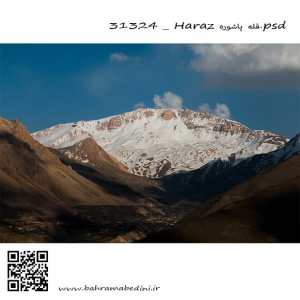
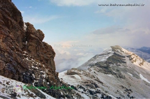
البرز شرقی قله پاشوره 3900 متر در جوار قله عبرت وقله امیری
This is a picture from the eastern Alborz mountain range. The peak in the picture is called Pashooreh, it has a height of 3900 meters from mean sea level which is (12795.28 ft) . the other summit beside it , is called Ebrat summit. and the other one, Amiri summit.
Mountain photography is the art of capturing nature at its core, and having the colors as natural as it can be. The framing is also important in mountain photography. it should be very inclusive of the nature around the mountains. Light in nature photography is important as to help viewers get the feeling of the nature right there. Therefore, it is not advisable to always have a bright and high visibility. Nature as it comes has darkness and brightness. there is sunrise and sunset and all makes different lighting in the atmosphere around it.
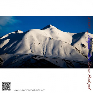
Shah Karam mountain
in the region of Taleghan, north central Iran
طالقان خچیره قله شاه کرم
عظمت و بزرگی کوه های ایران بسیار چشمگیر و زیبا هست و برف این زیبایی را دو چندان میکند. طالقان جزء روستاهایی هست که دور تا دور آن را کوه محاصره کرده و منطقه کوهستانی زیبایی رو به وجود آورده است.
برای خرید این عکس یا دیگر عکس های با ما تماس بگیرید.
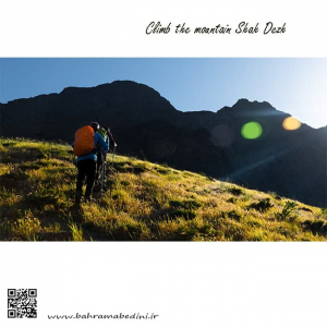
عکسی از صعود به قله شاه دژ در رشته کوه البرز
Hiking the Shah-Dej Summit
Shah-dej is part of the alborz mountain range which is located north iran. most of the summits are 13000 ft and up from mean sea level.
خط الراس شاه البرز با كوه هاي سالبرف، سیاهکوه ، سفید آب و قله خاس از روی تالاب اشتهارد
This is an image of the mountain ranges of Alborz from the Eshtehard lake.
The mountains in the background are Shah alborz, Sal-barf, Siyah-kooh, Sefid-Aab and the summit of Khaas.
This image is available for sale in the store.
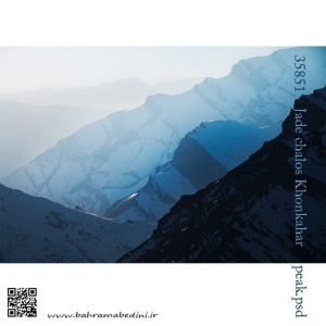
یال قله خونکهار
رشته کوه البرز
KhonKahar mountain
Alborz mountain ranges
North of Iran
عکس حاظر نمایی از قله ی کلون بستک است که با گروه کوهنوردی در چشم اندازی بی نظیر گرفته شده است. قله کلون بستک به ارتفاع 4156 متر از سطح دریا در استان تهران واقع است و جزء ارتفاعات البرز میباشد.
The overlook over the Kolun Bastak summit is a picture taken with hiking friends over a 4156 meters mountain peak in the heights of Tehran with beautiful sky and magnificent nature.
قله های شاه البرز که در شمال ایران قرار دارد شامل 5 قله میباشد که از فصل زمستان تا بعد از بهار همچنان پوشیده از برف است. رگه های صخره ای به این کوه در زمستان همراه با برف ابهت بسیاری میبخشد که در عکس فوق قابل مشاهده است.
The 5 peaks of Shah-Alborz or (King of Alborz) are situated in the northern part of Iran where the Alborz mountain series are. The boulder stony mountain and the snow make these peaks a very spectacular place to take pictures.
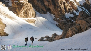
عکس فوق مربوط به صعود قله ی ناز و میشینه نو میباشد که در اویل فصل بهار گرفته شده است. در طول زمستان دره ی فوق که به قله ی ناز منتهی میشود کاملاً پوشیده از برف است و به صورت کامل راه مسدود میشود اما در بهار با آب شدن برف های میتوان از روی یخچال های برفی به سمت قله صعود کرد.
Above is a picture of the Hiking of the Mountain of Naaz and Mishine no peaks, taken in early spring. During the winter, the valley that leads to the summit is completely snow-covered and completely blocked off, but in the spring with snow melting it can be climbed to the summit through snow-covered glaciers.
قله ریزان در البرز مرکزی بخش لواسانات، نزدیکی روستای افجه قرار دارد. ارتفاع این قله 3700 متر از سطح دریا می باشد.این عکس از روی خط الراس آتشکوه گرفته شده است. برای رسیدن به این قله می توانید از دو مسیرِ دشت هویج و دشت گردو استفاده کنید. از روی قله ریزان می توان دشت لار و هم چنین قله دماوند را مشاهده کرد. از کوه های اطراف این قله می توان به سیاه چالِ یک و دو وسه،اَندَر، پُرسون، آتشکوه، مهرچال، و پیرزن گلون اشاره کرد. هم چنین آبشار سوستون نیز در این منطقه قرار دارد.
Rizan Peak is located in the central Alborz section of Lavasanat, near the village of Afjeh. The summit is 3700 meters above sea level. This photo was taken on a ridge of fire. To reach this peak you can use the two paths of carrot and walnut. From the summit of Lizan plain can be seen as well as Damavand peak. Mountains around the summit can be found in the dungeons of One and Two Vose, Ender, Persson, Atashkouh, Mehrchal, and Old Glen. There is also the Suston Falls in the area.